After having the hastings line go south through metrotown I think it's be cool if it went through a southern portion of Vancouver to loop back up too and connect with the millenium/evergreen line at UBC.
But then I don't have enough knowledge of the area to suggest a good ROW with either already established density along the route or potential density development.
Edit - Adding onto this post. I had time to kill, so for shits and giggles I drew up this little map of what I see a possible Skytrain system looking like by 2040:
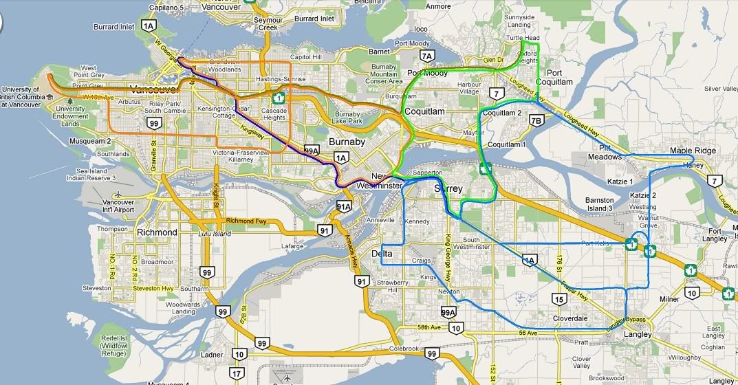
The Dark Blue would be along the same trackage as the current Expo line, and would continue to be called the Expo line. However, it becomes an express line only. The stations where it stops would be super-dense locations or main transfer points, which in this case would be either King George, Surrey Central, or Gateway in Surrey (if Gateway or Surrey Central, a second Surrey Express Station at Guilford could be considered), either Columbia or New West in New Westminster, Metrotown in Burnaby, Broadway/Commercial Drive and Waterfront in Vancouver.
The Gold would be along the same route as the upcoming Millenium Line extension and Evergreen Line. Stops would be on Campus, at the Broadway/City Hall transfer to Canada Line LRT, at the Broadway/Commercial drive Transfer to Expo Line & North Fraser/Millenium Loop, Brentwood Town Center transfer to North Fraser/Millenium loop, Cameron or Burquitlam transfer to Evergreen Loop, and Port Moody or Coquitlam Central with transfer to WCE.
I was considering making it one sole express line that would loop from Waterfront all the way around through Surrey and Coquitlam (following the green line, to be known as Evergreen Loop). If this were to happen, the train would maintain the name Expo Line, and would have an additional stop in Port Moody. The motivation behind that is that the South Frazer Loop (light blue) would benifit from having only one transfer to both UBC and Downtown Vancouver, rather then having to make 2 transfers onto the Evergreen Loop and then onto the Millenium Express to get to UBC, with 3 transfers to get onto the local North Fraser Loop, to be known as Millenium Loop if the Express lines are merged into one (orange line).
The orange coloured line could have any one of several names, but I'll call it North Fraser Loop, is a further extension of the currently known Millenium Line in both directions east from Waterfront and South out of UBC. Leaving Waterfront, it would head east along Hastings until Willingdon Ave. It would turn south along Willingdon, and stops would include a transfer point at Brentwood town Center to the Millenium Express and North Fraser Loop, a stop at BCIT, and probably another stop before the obvious transfer point at Metrotown to the Expo Line and North Fraser Loop. From there it would head west. As I said above I'm not to familiar with South Van, so I just choose an ROE that made sence from google maps. The train would head west along Imperial St. and continue along East 49th Ave. From there it goes north along Knight Street until 41st Ave., and would again head west until Dunbar Street. It turns north once more onto Dunbar, and then west again along West 16th onto the UBC Endowment lands, where it would loop up and around, connecting with currently planned Millenium Line Alignment.
As said above, the name could be changed to Millenium Loop if the two express lines are merged into the one Expo Line.
The green line would be known as the Evergreen Loop, and would follow the same route as the currently planned Evergreen Line and the north/south leg of the Millenium line, aswell as an extension going south through Port Moody, and across the new Port Mann to Surrey. The line wouldn't go through either Columbia or Lougheed stations, so transfers to express lines would have to be done at either one of the downtown Surrey stations, or the Burquitlam/Cameron Stations. Transfer to one of the North Fraser/Millenium Loop trains could either be done at Sapperton or Braid.
The Light Blue Line could be any one of several names, but I'm going to call it the South Fraser Loop. At first the line simply continues from Scott Road Station South. there would be a loop that connects to Skybridge aswell, but I'll get to that later. Going south from Scott Road the train would loop through Delta, eventually making it's way southeast to 56th ave. Again, I'm not to familiar with Delta, so I'll leave it up to you guys to argue the best ROE for the Delta/South Surrey area. From there it heads east with several stops in Cloverdale and Langley (4/5). From there in heads North. I've got three different ROEs laid out that are all vastly different, so I'm def. looking for comments and critisism here. The first line simply turns left on 72nd and eventually B-lines it back up into Surrey along the fraser highway, to reconnect with the Expo and Evergreen at either King George or Guilford. The second option heads east alogn 72nd, then north through to Walnut Grove and Port Kells, and then loops back down across the highway again and heads straight west along 88th until either the Fraser Highway going to King George, or north along 160th to get loop up and over to Guilford. I intentionally avoided the Native reserve and any possible headaches that could cause. The last line option would go through Port Kells and Walnut Grove along same route as option 2, again with 2 or more stations. For sake of Simplicity I just cut line straight through and across the river, when in reality I imagine it would weave around a bit so as to have stops near Colossus and the bridge. From there I don't know exactly where the line woudl cross the river, but after it does it would head east and loop through Maple Ridge, with a transfer point at the WCE stop before heading back weast to Pitt Meadows, across over into Port Coquitlam, and joining up with the Evergreen Loop at the Port Moody WCE Station. The Line would follow the Evergreen Loop through Surrey from there until Scott Road, however there would be trackage to head north along Evergreen (see below).
The express lines would be peak-hour only. Off peak hours the whole system would instead be served by a local train that does a giant loop. The line would start at Waterfront and follow the Expo Line route until it goes through Scott road, where it would take the above mentioned loop and then travel all around the South Fraser Loop into either Surrey or Port Coquitlam, where it would head North to the Millenium Express Line, and follow that route until UBC, where it would again start following the same routing as the North Fraser/Millenium Loop back to Waterfront. Keep in mind this only replacing the Express Line(s) in off-peak hours so as to provide a more convinient, 1 transfer only to most locations, while the Express Line(s) are more intended to get people from point A to point B faster, but with possibly more transfers depending on where you are coming from and where you are going.
The routing I have shown above I expect could be done by 2040.
Small Expo/Millenium Line extensions will be completed in the 2010-2020 timeframe (Expo east from Waterfront to Metrotown and King George to Guilford, Millenium to UBC and Douglas).
The Evergreen Loop and North Fraser/Millenium Loop would be completed in the 2020-2030 timeframe. In addition to the completion of these routes, branch lines that would eventually become the South Fraser Loop would leave Scott Road south into Delta, and East out of Port Coquitlam into Pitt Meadows and Maple Ridge (Once Evergreen Loop is completed). From there B-line buses would go along the rest of the intended ROE to spur densit development to warrant the creation of the rest of the line.
In the 2030-2040 timeframe the South Fraser Loop Line would be completed. Extensions to the size of the platforms along some of the already completed lines would be completed to service the express trains.
All throughout this timeframe new BRT lines would prove the routes that would eventually become the Skytrain Lines I have listed, aswell as feed the already completed lines along with an ever expanding streetcar/LRT network.
After 2040 the improvements to the transit system would be further extensions to train stations from 80 meters to 120 meters, and possibly even 160 meters for the express trainstations if possible. More Light Rail and Street cars would be developed in the low-medium desnity areas to spur development and feed the already established lines.
Something else I want done but failed to include were a South Fraser WCE line that goes through Richmond, Tsawassen, Delta, South Surrey, Langley, Aldergrove, Abottsford & Airport, all the way to Chillowack and possibly Hope. I would also have a WCE line that goes North to West Van, Horseshoe Bay, Saanich, and possibly even Whistler and Pemberton. The North Fraser Line would maintain it's approximate ROE, but get it's own dedicated trackage.
I would also have the HSR which leaves Vancouver and heads directly to the American Border, as the Abbotsford Airport would already be served by the WCE.
What Y'all think? And don't berate me for my diagram. All I have is MSPaint.


 Prev
Prev


 That raises a number of pertinent issues, like turnaround time, and possible "logjams" as well as the better restribution of busses.


 Linear Mode
