HomeDiagramsDatabaseMapsForum About
     

Go Back   SkyscraperPage Forum > Regional Sections > Canada > Alberta & British Columbia > Calgary > Transportation & Infrastructure


Reply

 
Thread Tools Display Modes
     
     
  #201  
Old Posted Oct 5, 2007, 10:16 PM
korzym's Avatar
korzym korzym is offline
Registered User
 
Join Date: Nov 2006
Posts: 703
Quote:
Originally Posted by freeweed View Post
So I still have 2 years till I can visit my friends in Strathmore without taking the really slow way.

Oh, and there's no apostrophe in "winters". Funny that someone would type one there, but not for the other pluralizations (even in the same sentence).

/spelling nazi mode off
I haphazardly stumbled upon a city link about 68th and 16th...apparently its been up since July, there was even an open house on the matter

http://www.calgary.ca/portal/server....nterchange.htm

and looks like we have an official pdf on 68th and 16th here:
http://www.calgary.ca/docgallery/bu/...house_june.pdf

quick facts:
Cost $60 million, plan a, city council approved..in 1978....no access what so ever going to stoney off 68th, and no access from stoney to 68th..
plan b: $100 M
plan c: $180 M....best design imo, too bad its most costly
-according to pdf, at this time city should be reviewing info session feedback..
-city and province working together..
Reply With Quote
     
     
  #202  
Old Posted Oct 5, 2007, 10:29 PM
You Need A Thneed's Avatar
You Need A Thneed You Need A Thneed is offline
Construction Enthusiast
 
Join Date: Feb 2007
Location: Castleridge, NE Calgary
Posts: 5,892
Quote:
Originally Posted by korzym View Post
I haphazardly stumbled upon a city link about 68th and 16th...apparently its been up since July, there was even an open house on the matter

http://www.calgary.ca/portal/server....nterchange.htm

and looks like we have an official pdf on 68th and 16th here:
http://www.calgary.ca/docgallery/bu/...house_june.pdf

quick facts:
Cost $60 million, plan a, city council approved..in 1978....no access what so ever going to stoney off 68th, and no access from stoney to 68th..
plan b: $100 M
plan c: $180 M....best design imo, too bad its most costly
-according to pdf, at this time city should be reviewing info session feedback..
-city and province working together..
Yeah, it was posted a while back. not a whole lot of discussion though. Again, I'm not sure how there's a 40 million dollar difference between plan a and plan b, it basically just two tiny one lane bridges added.

My preference would be that they do plan b.
Reply With Quote
     
     
  #203  
Old Posted Oct 21, 2007, 2:10 AM
korzym's Avatar
korzym korzym is offline
Registered User
 
Join Date: Nov 2006
Posts: 703
Concrete Support


Digging for Culvert


Aerial of Stoney Tr NE & Mcknight, looking south


Cranes and Girders [possibly part of 16th Ave overpass]


Aerial of Stoney Tr NE & 16th Ave, looking south


Aerial looking north taken from just south of Mcknight interchange


courtesy of: stoneytrailgroup.ca
Reply With Quote
     
     
  #204  
Old Posted Oct 21, 2007, 5:53 AM
korzym's Avatar
korzym korzym is offline
Registered User
 
Join Date: Nov 2006
Posts: 703
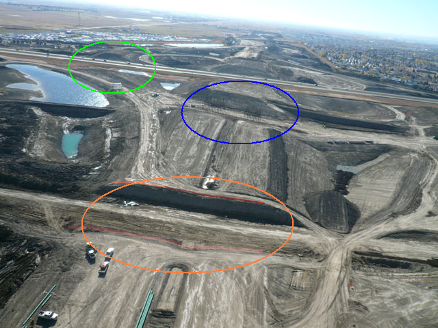
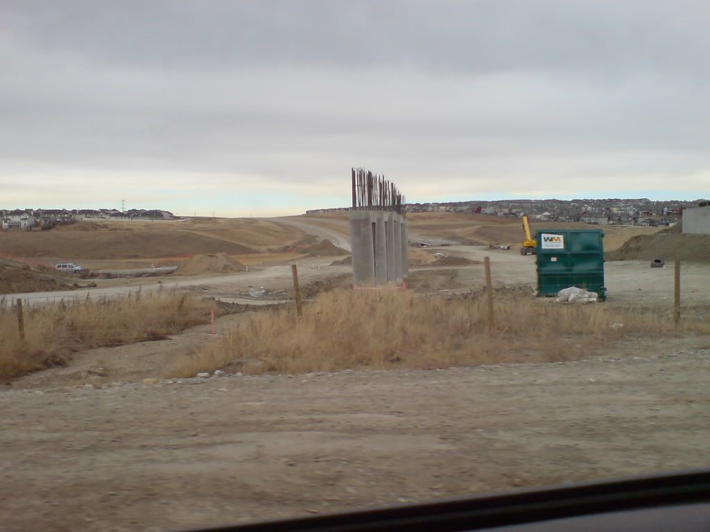
I was looking at this picture and noticed preparation for the flyover from north bound stoney towards west bound 16th. The area circled blue is where the planned underpass will be for that ramp, but notice the area circled green has a mound of dirt to support that over pass going over 16th also for the ramp.


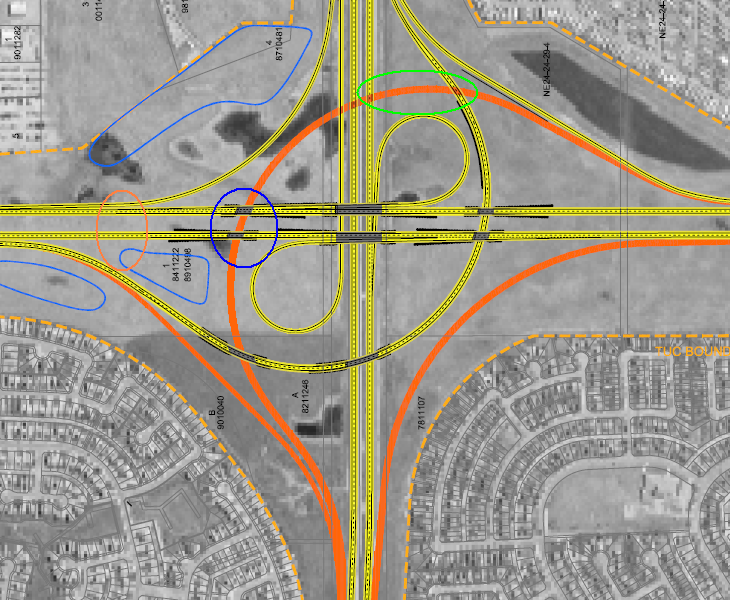
Now looking at the map, this ramp is planned to be built by 2017 or sooner as 16th and 68th doesn't have an interchange [full plans here http://www.infratrans.gov.ab.ca/INFT...ion/Board1.pdf ]. The orange overpass on this map according to stoney trail can't be built until there's an interchange built at 16th and 68th for free flow safety concerns. So what I'm alluding to, is whether there's an imminent announcement about building an overpass at 16th and 68th?

I can understand the reason why the underpass at the blue circle is being built, it would cause congestion later on and design wise it just makes sense to build it now. But they said they won't build that westbound turnoff thats orange on the map until the 16th & 68th interchange is built, yet their currently building it. City Hall starts meeting next month, maybe not at the next meeting but a little bit down the road in the not too distant future they'll announce plans to have the 16th & 68th interchange built by the time stoney trail ne is finished?
They may just be building the complex areas and won't open that ramp but it counters what their plans are that they emailed me [available on the previous thread page].


finally on an irrelevant matter, wtf is the area circled in orange for? Seems like its built up for some kind of bridge even though nothings planned for that area.

Last edited by korzym; Oct 21, 2007 at 6:50 AM. Reason: all italicized words were added
Reply With Quote
     
     
  #205  
Old Posted Oct 21, 2007, 6:24 AM
mersar's Avatar
mersar mersar is offline
Registered User
 
Join Date: May 2006
Location: Calgary, AB
Posts: 10,083
Hmm, the more I look at it the more it doesn't make sense. The spot on the picture in blue is too far south to be the underpass, but too far north to be 16th itself unless they've changed the plans since the maps I have were released.

I do believe that the 16th @ 68th interchange is going to end up on the books next year, they had an open house of sorts for it this past June.
__________________

Live or work in the Beltline? Check out the Official Beltline web site here

Last edited by mersar; Oct 21, 2007 at 6:42 AM.
Reply With Quote
     
     
  #206  
Old Posted Oct 21, 2007, 6:43 AM
korzym's Avatar
korzym korzym is offline
Registered User
 
Join Date: Nov 2006
Posts: 703
.
Reply With Quote
     
     
  #207  
Old Posted Oct 22, 2007, 4:12 AM
You Need A Thneed's Avatar
You Need A Thneed You Need A Thneed is offline
Construction Enthusiast
 
Join Date: Feb 2007
Location: Castleridge, NE Calgary
Posts: 5,892
I'm pretty sure 16th/68th will go ahead together with the SE ring road, which many of us here think will happen just after the NE is done, or while it's still going. They pretty much have to build 16th/68th when the ring road is extended south.

As for what's going on in that orange area circled, my guess is that they've just left an area open for ease of construction vehicle movement... unless there is some kind of interconnection between the two storm ponds on either side, and they have yet to put in the piping or something. I can't think of anything else that would go in that area.
Reply With Quote
     
     
  #208  
Old Posted Nov 12, 2007, 12:12 AM
freeweed's Avatar
freeweed freeweed is offline
Home of Hyperchange
 
Join Date: Sep 2006
Location: Dynamic City, Alberta
Posts: 17,566
Holy crap, we might actually see this Ring Road before I die:

They're paving the new parts of Stoney as I write this. Just north/east of Country Hills.

After watching some of this prep work last 12-18 months, I was seriously starting to wonder.
Reply With Quote
     
     
  #209  
Old Posted Nov 13, 2007, 8:22 PM
lubicon's Avatar
lubicon lubicon is offline
Suburban dweller
 
Join Date: Jun 2003
Location: Calgary - our road planners are as bad as yours Edmonton
Posts: 5,047
Quote:
Originally Posted by freeweed View Post
Holy crap, we might actually see this Ring Road before I die:

They're paving the new parts of Stoney as I write this. Just north/east of Country Hills.

After watching some of this prep work last 12-18 months, I was seriously starting to wonder.
Me too. There has not been much visible progress this summer it seems. Now if they would just provide a project update on the website.... twice a year updates is not asking too much is it??
__________________
Two things are infinite: the universe and human stupidity; and I'm not sure about the the universe.

Albert Einstein
Reply With Quote
     
     
  #210  
Old Posted Nov 13, 2007, 8:30 PM
mersar's Avatar
mersar mersar is offline
Registered User
 
Join Date: May 2006
Location: Calgary, AB
Posts: 10,083
I think a lot of this summer's progress was related to bridge work, the paving will take virtually no time to complete in comparison. The Country Hills bridge is probably about 80% done now, Shaganappi is done, Deerfoot Northbound is probably about 90% done from what I've heard, the CP bridge is complete, Sarcee is at least started and Crowchild is probably about 60%. I haven't been up near the Beddington bridge recently, but there were road closures/land reductions recently so I assume that something is at least happening.

I was looking at the work thats going on at Crowchild this morning, and it appears that whatever the province decided that they've haven't announced about the review for Rocky Ridge is that the intersection must go. The offramp from eastbound Crowchild to Southbound Stoney looks like it begins to the west of the existing Rocky Ridge intersection. And Mount Stoney is starting to disappear as well now, they've cut a good amount off the SW of the pile.
__________________

Live or work in the Beltline? Check out the Official Beltline web site here
Reply With Quote
     
     
  #211  
Old Posted Nov 13, 2007, 8:46 PM
freeweed's Avatar
freeweed freeweed is offline
Home of Hyperchange
 
Join Date: Sep 2006
Location: Dynamic City, Alberta
Posts: 17,566
Quote:
Originally Posted by mersar View Post
I was looking at the work thats going on at Crowchild this morning, and it appears that whatever the province decided that they've haven't announced about the review for Rocky Ridge is that the intersection must go. The offramp from eastbound Crowchild to Southbound Stoney looks like it begins to the west of the existing Rocky Ridge intersection. And Mount Stoney is starting to disappear as well now, they've cut a good amount off the SW of the pile.
This sure promises to be "interesting". The increase in traffic volume at the Country Hills/Royal Birch Blvd intersection in the past 12 months has been staggering. With the flurry of new condos still to come, and the rest of the neighbourhood filling up, it will soon be bumper-to-bumper coming in or going out of Royal Oak during the day. When the city closes Rocky Ridge Rd off, it's going to be a nightmare.

This may be the most poorly designed entrance to a neighbourhood I've ever seen. Tuscany is a close second, mind you.

Oh, and I thought we were calling it Tuscany Mountain. (Hint: "Mount" only comes first when it's named after a person)
Reply With Quote
     
     
  #212  
Old Posted Nov 13, 2007, 9:28 PM
mersar's Avatar
mersar mersar is offline
Registered User
 
Join Date: May 2006
Location: Calgary, AB
Posts: 10,083
Quote:
Originally Posted by freeweed View Post
This sure promises to be "interesting". The increase in traffic volume at the Country Hills/Royal Birch Blvd intersection in the past 12 months has been staggering. With the flurry of new condos still to come, and the rest of the neighbourhood filling up, it will soon be bumper-to-bumper coming in or going out of Royal Oak during the day. When the city closes Rocky Ridge Rd off, it's going to be a nightmare.
Especially if they close it before they finish building Country Hills through to 12 Mile Coulee. I suspect that the Country Hills/Stoney interchange may need to be bumped up on the list of which needs to be built to its final configuration sooner than later
__________________

Live or work in the Beltline? Check out the Official Beltline web site here
Reply With Quote
     
     
  #213  
Old Posted Nov 13, 2007, 9:48 PM
lubicon's Avatar
lubicon lubicon is offline
Suburban dweller
 
Join Date: Jun 2003
Location: Calgary - our road planners are as bad as yours Edmonton
Posts: 5,047
Quote:
Originally Posted by mersar View Post
Especially if they close it before they finish building Country Hills through to 12 Mile Coulee. I suspect that the Country Hills/Stoney interchange may need to be bumped up on the list of which needs to be built to its final configuration sooner than later
I still think the Crowchild / Stoney interchange is #1 on the lsit, especially now that the LRT is coming through as well. Country Hills might be next although I think Nose Hill Drive should be a priority.
__________________
Two things are infinite: the universe and human stupidity; and I'm not sure about the the universe.

Albert Einstein
Reply With Quote
     
     
  #214  
Old Posted Nov 13, 2007, 11:59 PM
The Chemist's Avatar
The Chemist The Chemist is offline
恭喜发财!
 
Join Date: Aug 2001
Location: 中国上海/Shanghai
Posts: 8,883
Quote:
Originally Posted by lubicon View Post
I still think the Crowchild / Stoney interchange is #1 on the lsit, especially now that the LRT is coming through as well. Country Hills might be next although I think Nose Hill Drive should be a priority.
I agree. The Nose Hill/Stoney interchange should definitely be added ASAP.
__________________
"Nothing is too wonderful to be true, if it be consistent with the laws of nature." - Michael Faraday (1791-1867)
Reply With Quote
     
     
  #215  
Old Posted Nov 14, 2007, 1:10 AM
mersar's Avatar
mersar mersar is offline
Registered User
 
Join Date: May 2006
Location: Calgary, AB
Posts: 10,083
Quote:
Originally Posted by lubicon View Post
I still think the Crowchild / Stoney interchange is #1 on the lsit, especially now that the LRT is coming through as well. Country Hills might be next although I think Nose Hill Drive should be a priority.
Agreed. Building Crowchild, and then Country Hills out is what I would hope is done, and start at least planning on the Nosehill one. It's needed, but unfortunately I don't think we'll see it for a bit.
__________________

Live or work in the Beltline? Check out the Official Beltline web site here
Reply With Quote
     
     
  #216  
Old Posted Nov 14, 2007, 2:02 AM
jcornell jcornell is offline
Registered User
 
Join Date: Jul 2007
Location: calgary
Posts: 10
Drove by the Beddington bridge the afternoon and they had 5 of the pillers in the middle i think thats all thats going it.
I drove by were the harvest hill bridge is going and i hate to say this but there had the concert forms for lights there 3 on each side and 1 on each side frather back on stoney. It dosnt look good.
Reply With Quote
     
     
  #217  
Old Posted Nov 14, 2007, 2:15 AM
mersar's Avatar
mersar mersar is offline
Registered User
 
Join Date: May 2006
Location: Calgary, AB
Posts: 10,083
The lights at Harvest Hills were expected, the official plan as we know it doesn't involve a light-free 'freeway' for a few years yet, unfortunately. In terms of work at Harvest hills, is there any sign of concrete work, or just earth moving? The plans that AB Transportation has up indicates that that will be a full intersection with no bridge at all for the time being.
__________________

Live or work in the Beltline? Check out the Official Beltline web site here
Reply With Quote
     
     
  #218  
Old Posted Nov 14, 2007, 2:23 AM
MalcolmTucker MalcolmTucker is offline
Registered User
 
Join Date: May 2007
Posts: 11,439
Quote:
Originally Posted by mersar View Post
Agreed. Building Crowchild, and then Country Hills out is what I would hope is done, and start at least planning on the Nosehill one. It's needed, but unfortunately I don't think we'll see it for a bit.
All of these except Nosehill are To Be Completed by the project end date (2009 they say)

Crowchild - Fall 2008
Country Hills - Fall 2008
Scenic Acres/Tuscany - Fall 2009

As for Nosehill Drive, I could seriously see it being swithced to a Right in, Right Off Access on both the west and east sides of Stoney. This would turn NW Stoney into a true freeway on the cheap.

I am very interested on access plans for Rocky Ridge, especially since the LRT is going to only complicate things. I think ultimately Rocky Ridge might be up the creek on this one. I forsee a greater use of 12 Mile Coulee Road in the futre. the Rocky Ridge ASP calls the access of Rocky Ridge Road to Crowchild a "temporary access"

As for ultimate build out (with roads on the brown lines, not just the yellow lines) I am going to be unusually pessimistic/optimistic (depending on your point of view). I think the city will implement smart growth principles enough to be able to cause the projected demand for the full build out to not occur. I also think Alberta's next government will chart a path away from roads once the initial builds of the 201 and 216 are done.
Reply With Quote
     
     
  #219  
Old Posted Nov 15, 2007, 7:59 AM
craner's Avatar
craner craner is offline
Go Tall or Go Home
 
Join Date: Mar 2007
Location: Calgary
Posts: 6,753
[QUOTE=kyle_olsen;3165707]All of these except Nosehill are To Be Completed by the project end date (2009 they say)

Crowchild - Fall 2008
Country Hills - Fall 2008
Scenic Acres/Tuscany - Fall 2009

As for Nosehill Drive, I could seriously see it being swithced to a Right in, Right Off Access on both the west and east sides of Stoney. This would turn NW Stoney into a true freeway on the cheap.

I am very interested on access plans for Rocky Ridge, especially since the LRT is going to only complicate things. I think ultimately Rocky Ridge might be up the creek on this one. I forsee a greater use of 12 Mile Coulee Road in the futre. the Rocky Ridge ASP calls the access of Rocky Ridge Road to Crowchild a "temporary access"

As for ultimate build out (with roads on the brown lines, not just the yellow lines) I am going to be unusually pessimistic/optimistic (depending on your point of view). I think the city will implement smart growth principles enough to be able to cause the projected demand for the full build out to not occur. I also think Alberta's next government will chart a path away from roads once the initial builds of the 201 and 216 are done.[/QUOTE]

Why ??
Reply With Quote
     
     
  #220  
Old Posted Nov 17, 2007, 10:33 PM
SubwayRev's Avatar
SubwayRev SubwayRev is offline
Registered User
 
Join Date: Aug 2007
Location: Calgary
Posts: 445
Stoney Trail photos...

Stoney Trail/Shaganappi Trail

Stoney Trail/Harvest Hills Blvd.

Stoney Trail/Sarcee Trail

Stoney Trail/Beddington Trail
Reply With Quote
     
     
This discussion thread continues

Use the page links to the lower-right to go to the next page for additional posts
 
 
Reply

Go Back   SkyscraperPage Forum > Regional Sections > Canada > Alberta & British Columbia > Calgary > Transportation & Infrastructure
Forum Jump


Forum Jump


All times are GMT. The time now is 12:28 AM.

     
SkyscraperPage.com - Archive - Privacy Statement - Top

Powered by vBulletin® Version 3.8.7
Copyright ©2000 - 2024, vBulletin Solutions, Inc.