HomeDiagramsDatabaseMapsForum About
     

Go Back   SkyscraperPage Forum > Regional Sections > Canada > Manitoba & Saskatchewan


Reply

 
Thread Tools Display Modes
     
     
  #421  
Old Posted Sep 17, 2008, 2:40 AM
rgalston's Avatar
rgalston rgalston is offline
Density and complexity
 
Join Date: Mar 2005
Location: Parish of St. John
Posts: 2,644
Let's take grainy B&W photos of Portage and Main in the middle of winter today and see how it compares to the dreariness of the intersection in 1962.

Anyway, THANK YOU for sharing these photos of the Merchant's Bank (Wheat Pool) building--the real first steel-framed high-rise in Winnipeg, and the one of the more unsung of the city's significant lost treasures. It's always been hard to find pictures it, especially ones from later than 1905.
Reply With Quote
     
     
  #422  
Old Posted Sep 17, 2008, 3:09 AM
Andy6's Avatar
Andy6 Andy6 is offline
Starring as himself
 
Join Date: Mar 2002
Location: Toronto Yorkville
Posts: 9,739
Quote:
Originally Posted by rgalston View Post
Let's take grainy B&W photos of Portage and Main in the middle of winter today and see how it compares to the dreariness of the intersection in 1962.

Anyway, THANK YOU for sharing these photos of the Merchant's Bank (Wheat Pool) building--the real first steel-framed high-rise in Winnipeg, and the one of the more unsung of the city's significant lost treasures. It's always been hard to find pictures it, especially ones from later than 1905.
I didn't know it was steel-framed. What was the year of the Merchants Bank? I have never seen postwar pictures of it and didn't know it was the Wheat Pool building latterly. Interesting.
__________________
crispy crunchy light and snappy
Reply With Quote
     
     
  #423  
Old Posted Sep 17, 2008, 3:20 AM
Only The Lonely..'s Avatar
Only The Lonely.. Only The Lonely.. is offline
Portage & Main 50 below
 
Join Date: Feb 2006
Location: Seattle
Posts: 4,871
Quote:
Originally Posted by rgalston View Post
Let's take grainy B&W photos of Portage and Main in the middle of winter today and see how it compares to the dreariness of the intersection in 1962.

Anyway, THANK YOU for sharing these photos of the Merchant's Bank (Wheat Pool) building--the real first steel-framed high-rise in Winnipeg, and the one of the more unsung of the city's significant lost treasures. It's always been hard to find pictures it, especially ones from later than 1905.
No problem, I thought you guys would enjoy them.

There's tons and tons of old photos like this kicking around the basement of my workplace.

I'll see what I can scan the next time i'm in the office.
__________________
WINNIPEG: Home of Canada's first skyscraper!
Reply With Quote
     
     
  #424  
Old Posted Sep 17, 2008, 3:24 AM
Andy6's Avatar
Andy6 Andy6 is offline
Starring as himself
 
Join Date: Mar 2002
Location: Toronto Yorkville
Posts: 9,739
By the way, someone is selling off tons of Winnipeg postcards (individually) on eBay at the moment. I don't really collect postcards but if anyone does there are some pretty nice old ones there.
__________________
crispy crunchy light and snappy
Reply With Quote
     
     
  #425  
Old Posted Sep 17, 2008, 3:10 PM
drew's Avatar
drew drew is offline
the first stamp is free
 
Join Date: Feb 2004
Location: Hippyville, Winnipeg
Posts: 8,010
Quote:
Originally Posted by Only The Lonely.. View Post
In front of the Eatons building, just look at how contemporary and eye pleasing the Dayton Building (Blush Ultraclub) looked at that time.

I am almost certain that original building burned down in the 60's.

I have the Portage Avenue coffee table book, and the building that stands there now (with the Blush club) was a rebuild on that site. Apparently when it was built is was heralded as one of the best examples of "modern" building design.
Reply With Quote
     
     
  #426  
Old Posted Sep 17, 2008, 7:50 PM
mrchristian's Avatar
mrchristian mrchristian is offline
Registered User
 
Join Date: Nov 2005
Location: Winnipeg
Posts: 77
Quote:
Originally Posted by rgalston View Post
Anyway, THANK YOU for sharing these photos of the Merchant's Bank (Wheat Pool) building--the real first steel-framed high-rise in Winnipeg, and the one of the more unsung of the city's significant lost treasures. It's always been hard to find pictures it, especially ones from later than 1905.
Yes, thank you very much for taking the time to do that. Really help me to fill in my understanding of the history of that intersection. Great stuff !
__________________
Also check out my Winnipeg Photo Page, my Winnipeg history page and my blog West End Dumplings
Reply With Quote
     
     
  #427  
Old Posted Sep 17, 2008, 9:35 PM
rgalston's Avatar
rgalston rgalston is offline
Density and complexity
 
Join Date: Mar 2005
Location: Parish of St. John
Posts: 2,644
Andy, the Merchant's Bank was built in 1900. I'd imagine it was the tallest in the city before the Union Bank tower was finished.

Drew, the modern building that Blush nightclub is in was built after the fire in 1954 that wrecked the Time Building and another large structure across Hargrave (where the RBC is now). I don't know when it replaced it, but I imagine sometime before the 1950s were out.

Interestingly, the sketchy bar that operated there in the 1990s (and supposedly was the birthplace of Aboriginal street gangs in Winnipeg) was called the Times Nightclub.
Reply With Quote
     
     
  #428  
Old Posted Sep 17, 2008, 10:27 PM
Only The Lonely..'s Avatar
Only The Lonely.. Only The Lonely.. is offline
Portage & Main 50 below
 
Join Date: Feb 2006
Location: Seattle
Posts: 4,871
Quote:
Originally Posted by rgalston View Post
Andy, the Merchant's Bank was built in 1900. I'd imagine it was the tallest in the city before the Union Bank tower was finished.

Drew, the modern building that Blush nightclub is in was built after the fire in 1954 that wrecked the Time Building and another large structure across Hargrave (where the RBC is now). I don't know when it replaced it, but I imagine sometime before the 1950s were out.

Interestingly, the sketchy bar that operated there in the 1990s (and supposedly was the birthplace of Aboriginal street gangs in Winnipeg) was called the Times Nightclub.
Yes, I remember the Times Nightclub.

This city is a much better place because the Times and neighbouring Portage Village Inn are gone

If I remember correctly, it was because some woman had her throat slit inside that the place was closed.
__________________
WINNIPEG: Home of Canada's first skyscraper!
Reply With Quote
     
     
  #429  
Old Posted Sep 18, 2008, 12:46 AM
Andy6's Avatar
Andy6 Andy6 is offline
Starring as himself
 
Join Date: Mar 2002
Location: Toronto Yorkville
Posts: 9,739
On one of my old Winnipeg photo threads, I got a question from a gentleman in Winnipeg who lives in the Ellesmere Apts. on Carlton (because I'd posted this photo of the building two summers ago):


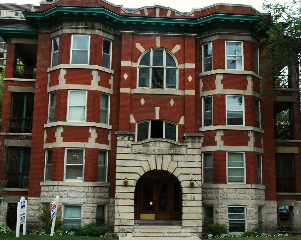
He wants to know where to find other photos or information about the building (for restoration and renovation purposes).

I have looked at online sources and have at least some answers (but no more photos).

(1) According to the City of Winnipeg's Assessments Database, the building was built in 1911.

(2) It does not appear in the 1911 Census of Canada, which was taken in June 1911. This suggests that it may have been occupied for the first time at some point in the second half of 1911.

(3) The only city directory that I have access to, the 1922 Henderson Directory, shows fifteen apartments 1-16 (except 13), all occupied. This appears to be the same configuration as exists today.

(4) Just out of curiosity, I looked through the online archive of the Winnipeg Free Press (part of my subscription to Ancestry.com) and found a lot of ads for suites for rent over the years. While these are invariably very brief classified ads, they do yield a bit of history if you read them closely enough.

(a) In the early years around World War I, the ads always mention that the building is fireproof (a big selling point) and are always for undivided 5 room suites. They also always mention that the apartment has a balcony, described as "private", "screened" or in one case as a "sleeping balcony". The amount of rent is never specified.

(b) Then in the 1930s, during the Depression, there are a bunch of ads for rooms or "bed-sits" -- this clearly suggests that by this time either the tenants or the landlords were dividing many of the units up. Even though I could only look at a few of what were probably dozens of them, there were ads for Suite 15 (Sept. 18, 1935) as a "bed-sitting room" and for a "large room" in Suite 11 (April 21, 1935). In ads from 1935 for what look to be entire suites, the rent was $55, rising to $58 in 1937. This was fairly high compared to other buildings advertised, although the 5 room suites are unusually large as well.

(c) The coverage of the FP archive is spotty, but there are a few references in the postwar years as well. There was an ad from May 2, 1950 for a "bed-sitting room" in Suite 5 and another on Sept. 3, 1960 stating the rent for a suite as $95. On April 10, 1965 the rent was still $95 but the ad mentions a "modern kitchen", which could suggest a renovation around that time.

(d) Almost all of the ads direct replies to the janitor or caretaker in Suite 1.

So I would get from this that the building was originally expensive because of the large suites, solid fireproof construction, and extravagant balconies, that as the Broadway area turned seedy in the Depression (and as people generallly ran out of money) a lot of tenants rented out a spare room or two to help make ends meet and that by the late 50s or early 60s some renovations were done to modernize bathrooms and kitchens.

If anyone has researched buildings or has suggestions about where to find plans or photos, please add them in this thread.
__________________
crispy crunchy light and snappy
Reply With Quote
     
     
  #430  
Old Posted Sep 19, 2008, 2:24 PM
sledhead35's Avatar
sledhead35 sledhead35 is offline
Registered User
 
Join Date: Jun 2008
Location: winnipeg
Posts: 327
in my google adventures, i stumbled accross this page. some reallly good pics from back in the day!


http://bbhilda.topcities.com/WinnipegThen_Now.html
Reply With Quote
     
     
  #431  
Old Posted Oct 2, 2008, 11:24 PM
1ajs's Avatar
1ajs 1ajs is offline
ʇɥƃıuʞ -*ʞpʇ*-
 
Join Date: Jul 2005
Location: lynn lake
Posts: 25,867
so the bus depo used to be on graham?

Reply With Quote
     
     
  #432  
Old Posted Oct 3, 2008, 4:03 PM
Archiseek's Avatar
Archiseek Archiseek is offline
http://www.archiseek.com
 
Join Date: Jan 2003
Location: Dublin / Winnipeg
Posts: 1,373
yeah Eatons paid for a bus station i believe, so out-of-towners would be basically dropped at their door and not at the bay
Reply With Quote
     
     
  #433  
Old Posted Oct 3, 2008, 4:18 PM
Biff's Avatar
Biff Biff is offline
What could go wrong?
 
Join Date: Jun 2004
Location: Winnipeg
Posts: 8,738
It sure would look nice to have that still there on that wind swept lot that is there now. Maybe the city can build a new style transit centre there to act as the hub for the Graham Ave transit mall.
Reply With Quote
     
     
  #434  
Old Posted Oct 3, 2008, 5:16 PM
Kinguni's Avatar
Kinguni Kinguni is online now
Registered User
 
Join Date: Mar 2008
Location: Manitoba
Posts: 1,417
Quote:
Originally Posted by Biff View Post
It sure would look nice to have that still there on that wind swept lot that is there now. Maybe the city can build a new style transit centre there to act as the hub for the Graham Ave transit mall.
If I've been told correctly the original plans for the Graham Ave. Transit Mall would have seen no car traffic on Graham from Main St. to Vaughn St. and, quite possibly in that lot, a downtown Transit terminal. I think area businesses objected though. I'd still like to see something like that, with buses arriving and leaving close together so that connections could be conveniently made. All Winnipeg Transit has concerned themselves with is operating each line as efficiently as possible without regard to transfer connections.
Reply With Quote
     
     
  #435  
Old Posted Oct 5, 2008, 4:40 PM
Andy6's Avatar
Andy6 Andy6 is offline
Starring as himself
 
Join Date: Mar 2002
Location: Toronto Yorkville
Posts: 9,739
delete...see below
__________________
crispy crunchy light and snappy
Reply With Quote
     
     
  #436  
Old Posted Oct 5, 2008, 4:41 PM
Andy6's Avatar
Andy6 Andy6 is offline
Starring as himself
 
Join Date: Mar 2002
Location: Toronto Yorkville
Posts: 9,739
Two new acquisitions representing the early 1960s:

Downtown / North End / EK, labelled "1962":


The clarity on the full-size version of this is pretty amazing; you can see every house:

link

City of Winnipeg, 1964:


Full size: link

Note that in the photo you can see the Disraeli Bridge and Freeway under construction, and in the map from two years later the Disraeli continues to empty onto Lily Street and on to Main Street via the block of James Avenue that was soon to be eliminated to make way for the Museum and Concert Hall. I wonder what the hold-up was in completing the Disraeli connection to Main Street. You can see that the bridge was built first, and that at the time of this photo the overpass section was underway, with demolition of the existing neighbourhood underway to the southwest, where the road was shortly to be extended toward Main. City Hall, which was demolished in 1962, still appears in the photo.

The 1964 map (I was born that year at the Grace Hospital in Wolseley) labels the Eaton "Bus Depot" on Graham, but includes the "New Bus Depot" at Portage and Colony. It also captures the transitional stage of redevelopment of the City Hall, with the new council and adminstration building apparently represented but the old city hall annex buildings and the old police headquarters on Rupert still existing. There's also the old CPR spur line running between Ross and Pacific Avenues into the north end of the Exchange District.
__________________
crispy crunchy light and snappy
Reply With Quote
     
     
  #437  
Old Posted Oct 5, 2008, 5:01 PM
Andy6's Avatar
Andy6 Andy6 is offline
Starring as himself
 
Join Date: Mar 2002
Location: Toronto Yorkville
Posts: 9,739
Another thing you can see on the map is that the traffic-flow engineers haven't quite had their way with the city yet. The paired one-way streets on Smith/Donald and King/Princess exist, but the extensions of Broadway, St. Mary Av., and Cumberland Av. are still in the future. Also no "Metro Routes" yet, with Balmoral and Notre Dame being labelled as part of Provincial Trunk Highway No. 6, and Higgins and Marion Sts. being labelled as spurs of Hwy. 59 (59B and 59A, respectively).
__________________
crispy crunchy light and snappy
Reply With Quote
     
     
  #438  
Old Posted Oct 5, 2008, 8:46 PM
rgalston's Avatar
rgalston rgalston is offline
Density and complexity
 
Join Date: Mar 2005
Location: Parish of St. John
Posts: 2,644
Quote:
Originally Posted by Andy6 View Post
The clarity on the full-size version of this is pretty amazing; you can see every house:
Indeed you can. I spotted my own.

Interesting thing I noticed on the map was what became the site of the Pan-Am pool, labelled as "park". I believe this was shortly after the last residents of "Rooster Town", the shanty-town that existed in that vicinity, were evicted. Does anyone know anything about Rooster Town?
Reply With Quote
     
     
  #439  
Old Posted Oct 6, 2008, 2:12 AM
1ajs's Avatar
1ajs 1ajs is offline
ʇɥƃıuʞ -*ʞpʇ*-
 
Join Date: Jul 2005
Location: lynn lake
Posts: 25,867
interesting to see a baseball diamond at the end of my st dam i don't think u could even fit one there today the way the bank has shifted...

o and does anyone have photos of the entire vulcan iron works complex speacly the bit across southerland that is now joe zuken heritage park

Last edited by 1ajs; Oct 6, 2008 at 2:28 AM.
Reply With Quote
     
     
  #440  
Old Posted Oct 6, 2008, 2:13 PM
Biff's Avatar
Biff Biff is offline
What could go wrong?
 
Join Date: Jun 2004
Location: Winnipeg
Posts: 8,738
Something else neat on that photo of Winnipeg, if you look way down Henderson Hwy you can make out the remains of what looks like a drive in theater Henderson and Mcleod. Can anyone confirm this? Now it is the shopping area with the Sobey's and McDick's.
Reply With Quote
     
     
This discussion thread continues

Use the page links to the lower-right to go to the next page for additional posts
 
 
Reply

Go Back   SkyscraperPage Forum > Regional Sections > Canada > Manitoba & Saskatchewan
Forum Jump


Forum Jump


All times are GMT. The time now is 3:02 AM.

     
SkyscraperPage.com - Archive - Privacy Statement - Top

Powered by vBulletin® Version 3.8.7
Copyright ©2000 - 2024, vBulletin Solutions, Inc.