HomeDiagramsDatabaseMapsForum About
     

Go Back   SkyscraperPage Forum > Regional Sections > Canada > Ontario > Hamilton > Hamilton Photos


Reply

 
Thread Tools Display Modes
     
     
  #21  
Old Posted May 28, 2008, 10:51 AM
stuckinexeter stuckinexeter is offline
Registered User
 
Join Date: May 2008
Posts: 62
Re: HSR 197

No way in photo to confirm year except the car next to the bus. It certainly looks more 60ish rather then something from early 50's, even the clothes on the pedestrians suggest the year is correct..... can anyone help?
Reply With Quote
     
     
  #22  
Old Posted May 28, 2008, 12:38 PM
stuckinexeter stuckinexeter is offline
Registered User
 
Join Date: May 2008
Posts: 62
Hsr 197

I blew up the photo section for anyone to identify the model year of the car.... also gonna show my mechanic. So what year is the car in the photo below. The picture was taken circa 1960.
Reply With Quote
     
     
  #23  
Old Posted May 28, 2008, 2:06 PM
Jaborandi's Avatar
Jaborandi Jaborandi is online now
Registered User
 
Join Date: Mar 2007
Location: Toronto
Posts: 194
[QUOTE=hamtransithistory;3578294]

well, that is definitely a 1959 Chevrolet beside the bus.

Last edited by Jaborandi; May 29, 2008 at 2:14 AM.
Reply With Quote
     
     
  #24  
Old Posted May 28, 2008, 3:19 PM
Jon Dalton's Avatar
Jon Dalton Jon Dalton is offline
Registered User
 
Join Date: Aug 2007
Location: Hamilton
Posts: 1,778
I'd be interested to see the Jackson Square area buildings in the years leading up to demolition. I've seen the pictures from their glory days but I wonder just how bad did it get?
__________________
360º of Hamilton
Reply With Quote
     
     
  #25  
Old Posted May 28, 2008, 3:25 PM
DC83 DC83 is offline
Closed account
 
Join Date: Sep 2006
Posts: 2,430
^^ From what I hear, York Blvd especially was pretty bad... like Barton St bad.
I have no clue, I'm way too young to remember anything like that. This info is from my family.
Reply With Quote
     
     
  #26  
Old Posted May 28, 2008, 5:01 PM
stuckinexeter stuckinexeter is offline
Registered User
 
Join Date: May 2008
Posts: 62
Jon's request re: pre Jackson Square pics.......

Here are some pics before Jackson Square was built.... what a seedy area.


Reply With Quote
     
     
  #27  
Old Posted May 28, 2008, 6:08 PM
flar's Avatar
flar flar is online now
..........
 
Join Date: Jan 2006
Location: Southwestern Ontario
Posts: 15,182
What a serious loss. I'd gladly trade Jackson Square and even Stelco Tower to have that great streetwall back.
__________________
RECENT PHOTOS:
TORONTOSAN FRANCISCO ROCHESTER, NYHAMILTONGODERICH, ON WHEATLEY, ONCOBOURG, ONLAS VEGASLOS ANGELES
Reply With Quote
     
     
  #28  
Old Posted May 28, 2008, 6:34 PM
stuckinexeter stuckinexeter is offline
Registered User
 
Join Date: May 2008
Posts: 62
Photos wanted.......

If you have or have access to any photos to the east end power line corridor could you please post. This includes views on Stratherne Ave, Bell Ave, or area south of TH&B tracks.
The original 1898 power line does still exist in Smithville, and
Ontario hydro left one tower standing with a plaque at Greenhill Ave. Photos should be from the 50's or earlier.
Also, anyone with any photo of the Piggott bldg. when the spire was illuminated at night by white lights or colored at Christmas please submit.
I know these may be hard to come by but someone somewhere will have some pics..... thanks.....
Reply With Quote
     
     
  #29  
Old Posted May 28, 2008, 8:00 PM
BrianE's Avatar
BrianE BrianE is offline
Registered User
 
Join Date: Dec 2007
Location: Hamilton
Posts: 352
When looking at the air photos what buildings are everybody using to orient themselves? Personally, my eye is always drawn to either the Lister or the Pigott building and then I think, "ah! now I know what I'm looking at"
Reply With Quote
     
     
  #30  
Old Posted May 28, 2008, 8:14 PM
Jaborandi's Avatar
Jaborandi Jaborandi is online now
Registered User
 
Join Date: Mar 2007
Location: Toronto
Posts: 194
What is particularly distressing about the destruction of much of downtown in the name of urban renewal, is that much of that land stood empty for a very long time - long enough for amusement park rides to be set up at King & James!!!! Hamilton has never recovered from such wanton destruction and it is galling that the present City government hasn't learnt a damn thing from this tragedy.
Reply With Quote
     
     
  #31  
Old Posted May 28, 2008, 8:18 PM
stuckinexeter stuckinexeter is offline
Registered User
 
Join Date: May 2008
Posts: 62
LOL.... Pigott bldg.....

when i was in grade 7 at Viscount Montgomery School. my math teacher would say... if you don't pass this test then go jump off the Pigott bldg. That was in 1956. When i married he became a cousin.... small world eh?
anyhow back in the 50's the Pigott bldg was the key focal point.... I even got to ride to the top and have a look in 1958.
Reply With Quote
     
     
  #32  
Old Posted May 28, 2008, 8:21 PM
matt602's Avatar
matt602 matt602 is offline
Hammer'd
 
Join Date: Jan 2006
Location: Hamilton, ON
Posts: 4,755
I think things could have been a lot worse. At least we did get the construction of City Hall, the Art Gallery, Board of Ed. building, Stelco Tower, Jackson Square, etc. It would have been so much worse if those buildings were simply ripped down. We wouldn't even have a downtown if that were the case. At the time, building all of those civic buildings was probably almost as ambitious as Harry Stinson's 100 story tower is now.
__________________
"Above all, Hamilton must learn to think like a city, not a suburban hybrid where residents drive everywhere. What makes Hamilton interesting is the fact it's a city. The sprawl that surrounds it, which can be found all over North America, is running out of time."
Reply With Quote
     
     
  #33  
Old Posted May 28, 2008, 8:24 PM
stuckinexeter stuckinexeter is offline
Registered User
 
Join Date: May 2008
Posts: 62
Jaborandi.... send in the clowns

Heck, I remember working at Westinghouse at JS in the Thompson Bldg and going to Tim Hortons on King west at 3 a.m. in the morning and seeing the clowns and so forth from the construction of JS to the west towards Bay St.. What a hoot..... i loved each minute of it.....
Reply With Quote
     
     
  #34  
Old Posted May 28, 2008, 9:57 PM
SteelTown's Avatar
SteelTown SteelTown is offline
It's Hammer Time
 
Join Date: Mar 2004
Location: Hamilton
Posts: 19,880
I dunno and I'm probably going to get grilled for this but I don't think there anything particularly special with what was replaced by Jackson Square.

I definitely do see the destruction by York Boulevard (old City Hall and Market Square) though.
Reply With Quote
     
     
  #35  
Old Posted May 28, 2008, 10:53 PM
go_leafs_go02 go_leafs_go02 is offline
Registered User
 
Join Date: Dec 2007
Location: London, ON
Posts: 2,406
Quote:
Originally Posted by stuckinexeter View Post
If you have or have access to any photos to the east end power line corridor could you please post. This includes views on Stratherne Ave, Bell Ave, or area south of TH&B tracks.
The original 1898 power line does still exist in Smithville, and
Ontario hydro left one tower standing with a plaque at Greenhill Ave. Photos should be from the 50's or earlier.
Also, you can follow the line going along Metler road in Pelham. I used to live right on Metler Rd there last summer when I worked, and yeah, it's not in use, but fascinating to follow, as many of the powerlines are old and overgrown.

I believe that is the line you are talking about. (powerline)
Reply With Quote
     
     
  #36  
Old Posted May 29, 2008, 4:54 AM
Millstone Millstone is offline
Registered User
 
Join Date: Feb 2008
Location: Port Colborne, ON
Posts: 889


This is probably the most disconcerting shot...

Think of what's there now if you were to stand on that spot on the roof of Jackson Square. Hardly any shops left along James and King William to generate that kind of foot traffic, Zellers is now a dead parking lot, York Street doesn't even exist anymore, the Lister's been left to rot and the property next to it to fall down. Two-way traffic on King William (cars parked the opposite way). City Hall has been replaced with City Mall.

Grafton's looks gorgeous in this pic.

The pic below this one with "expropriation sale" in the windows is even more
Reply With Quote
     
     
  #37  
Old Posted May 29, 2008, 5:07 AM
hamtransithistory's Avatar
hamtransithistory hamtransithistory is offline
Registered User
 
Join Date: Mar 2008
Posts: 67
Quote:
Originally Posted by hamtransithistory View Post


My records say that HSR 197 was sold to the Canada Coach Lines in 1951. Is there any way we can confirm the date of this picture?
Forget I asked. I went through my notes a second time, and though I confirmed that HSR 197 did go to the CCL, I could not find any mention of when it was sold. Since this photo is probably correctly dated, I'll add it to my records.
Reply With Quote
     
     
  #38  
Old Posted Jul 31, 2009, 10:06 AM
stuckinexeter stuckinexeter is offline
Registered User
 
Join Date: May 2008
Posts: 62
A few power pics

Came across some photos of stuff you may c but never take note of. Feel free to add photos of similar items below. All pictures courtesy of archive.org and are in the public domain.

The developement of electrical power started about 1900 from the Niagara area to points in Ontario. Here are some early pics of the transmission lines/towers and some still do exist.

The pic below is the Niagara/Dundas/London corridor line. This view looks north towards the Dundas substation. The line on right is incoming from Niagara, the line on left outgoing to London. This line still exists today from Dundas to Ingersoll and also along Hwy 6 from Waterdown to Guelph.


The next pic is of the same line while workers erected the towers. Note the fact no safety gear......


Next is that same line from Niagara Falls at the Welland Canal. Note the workmen on the canal tower finishing it off while the line is only strung to the shorter tower on the left.


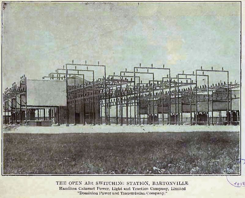
Next is the switching station from the first line to reach Hamilton, before Niagara power lines. This station served the line from Decew Falls to Hamilton and was situated north of CNR tracks at Strathearne Ave in Hamilton


This power line below ran from Niagara Falls ON via Chippewa, Fort Erie & Buffalo to Syracuse NY.


This line was part of the original Niagara to London Line. It still exists today running from London to Stratford.


This dual line ran from Niagara along the escarpment to a point near Stoney Creek at Ridge Rd. It then descended and travelled diagonally across the beach strip, where it headed northease across Burlington, meeting with the CNR tracks past Guelph Line. This line may still exist in the Hwy 20 Fonthill area.


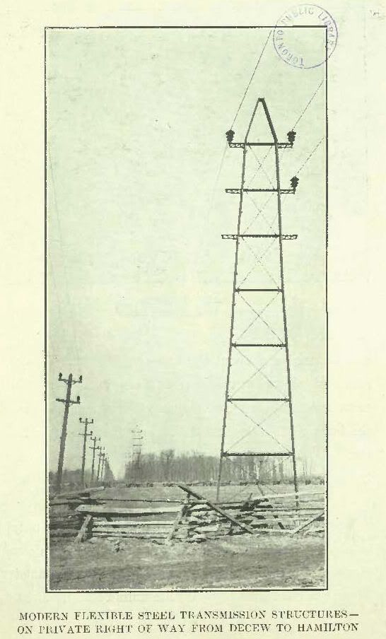
Finally the original Decew Falls line to Hamilton. Part of this line still exists in the Pelham area. Ontario Hydro left one tower standing to mark the historical
site of the line to Hamilton. It stands at Greenhill Ave at the foot of Cochrane Rd.
Reply With Quote
     
     
  #39  
Old Posted Jan 23, 2010, 9:24 PM
Rene Craik Rene Craik is offline
Registered User
 
Join Date: Jan 2010
Posts: 2
HSR 197 King and James

This picture must have been taken no earlier than 1957. Notice the car next to HSR 197 has double headlamps.

I love these pictures. Would love to see more.
Reply With Quote
     
     
  #40  
Old Posted Jan 26, 2010, 1:18 PM
Rene Craik Rene Craik is offline
Registered User
 
Join Date: Jan 2010
Posts: 2
I would love to view your pics, but I keep getting the message to Upgrade - Insufficient Band Width. Do I have to go into Photo Bucket to view these pics?
Reply With Quote
     
     
This discussion thread continues

Use the page links to the lower-right to go to the next page for additional posts
 
 
Reply

Go Back   SkyscraperPage Forum > Regional Sections > Canada > Ontario > Hamilton > Hamilton Photos
Forum Jump


Forum Jump


All times are GMT. The time now is 8:53 PM.

     
SkyscraperPage.com - Archive - Privacy Statement - Top

Powered by vBulletin® Version 3.8.7
Copyright ©2000 - 2024, vBulletin Solutions, Inc.