HomeDiagramsDatabaseMapsForum About
     

Go Back   SkyscraperPage Forum > Regional Sections > Canada > Alberta & British Columbia > Vancouver > Transportation & Infrastructure


Reply

 
Thread Tools Display Modes
     
     
  #701  
Old Posted Feb 19, 2012, 8:40 PM
trofirhen trofirhen is offline
Registered User
 
Join Date: Oct 2008
Posts: 8,840
Quote:
Originally Posted by Chikinlittle View Post
If line that came down Hastings, through Gastown to Waterfront, continued to Coal Harbour, Denman/Georgia, English Bay, and then across to Kits, Beach, Arbutus/4th, Broadway/Arbutus to meet UBC line, I think it would be quite beneficial. If would give people from the West Side a more direct connection to downtown. No not as direct as straight up Burrard street, but would also allow connecting much of the West End and Coal Harbour to the rapid transit network.


That's exactly something I've dreamed for ages!! (do you know how to draw that? I'd love to see a render)

In fact, I'd like to add that IMO, although the upcoming Evergreen Line, and the prospective extension of the M Line to UBC, both represent the culmination and completion of the RRT system in Vancouver for the foreseeable future, this line mentioned above could, and should, be added to the "completion" of the Vancouver RRT system. It could be called anything but something like the Transbay like would convey its direction, and its east-west reach across town
Reply With Quote
     
     
  #702  
Old Posted Feb 19, 2012, 11:33 PM
Canadian Mind's Avatar
Canadian Mind Canadian Mind is offline
Registered User
 
Join Date: Aug 2006
Posts: 3,921
Why waste the money having the Hastings Line loop around? Build it in stages. First stage running east to atleast Boundary, if not all the way to Wellingdon/BCIT. Second stage to Metrotown. Then third stage go back to Waterfront, build another platform to the north to avoid scheduling conflicts with trains, and run a line up Pender, loop it through the west end, under False Creek, to the Broadway extension. Eventually have the end at Metrotown and the end at the Broadway extension expanded so they meet in southwest Vancouver.

This will serve the northern portion of the penninsula, and end up being a far more productive and usefull line than a loop ever would be. If you still have a hard on for a downtown specific line, you could have the line branch off in the West End and hit up Roundhouse and Stadium stations before re-merging with the line somewhere in Chinatown to form a loop.
__________________
"you're eating chicken periods" - Vid
"I love eggs, especially the ones with runny yolks" - Me
"EWWWWWWWWWWWWWWWWWWWWWW, you're disgusting!" - Vid
Reply With Quote
     
     
  #703  
Old Posted Feb 20, 2012, 1:28 AM
Chikinlittle Chikinlittle is offline
Registered User
 
Join Date: Sep 2008
Posts: 264
Here's some various alignments and options, and potential extensions beyond the inner city to include the much-discussed 'loop'.

Starting with option 1 as I previously described, station at Broadway/Arbutus with connection to UBC line. Next stop West 4th Ave. Next Stop, Kits Beach. Lots of room there for a station house where grass/parking lot currently exists at the corner of Arbutus/Cornwall. From there, over to English Bay I would love to see the foot of Davie Street eliminated to terminate at Denman. Also remove Beach Ave from Denman to Morton. That would allow for a large public plaza, and amazing portal for a subway station. You would essentially walk out of the station at a giant square that opens up onto English Bay Beach. Next stop, up Denman Street somewhere near the corner of Robson and Denman. From there, it would head eastbound under Georgia with the next stop would provide a station entrance at the small triangle grassy patch at Nicola/Pender/Georgia. Nicola could be closed off as a through street there to provide for more space. From there the line would continue under Pender to roughly Thurlow where it would turn north to join the end of the Dunsmuir tunnel and existing Skytrain tracks. It would use the existing tracks and platforms at Waterfront before continuing east along the north edge of Gastown, dropping below grade once again with a station under Carrall Street (could provide station entrances right at Maple Tree Square, and another at Pigeon Park Square. From there, head east under Hastings...

Option 2 would provide the same path through to Robson/Denman, where it would instead run under Robson Street. Next stop under Bute Street. Following stop could finally incorporate Robson Square before continuing up to Richards street. While I admit it would be hard for it to turn north on Richards (unless quickly included in the Telus Garden design, or dug extremely deep afterwards), I thought about using Richards Street up towards Cordova to take advantage of the old post office tunnel. A station platform could be located as far north on Richards, providing connection to Waterfront Station, before heading east under Water Street, station at Water/Carrall (Maple Tree Square) before heading southeast to follow a Hastings Street alignment from there eastward.

Option 3 would be a hybrid of options 1/2 where it would follow Option 1 alignment to Melville/Thurlow, heading east under Melville and joining the Dunsmuir tunnel eastbound right at Burrard station, using those existing platforms. Continuing on along the same tracks through Granville station, it would then turn north on Richards to use the post office tunnel, and follow the alignment from there as described in option 2.

Option 4 would be elevated from Broadway/Arbutus following the existing tracks (station at Burrard), before submerging below grade somewhere east of Pine Street. From there it would travel underground, providing a station on Granville Island. Next stop on the north side of False Creek would be at the corner of Davie/Thurlow. Following under Thurlow northward, next stop, Thurlow/Robson, before again meeting up with the Dunsmuir tunnel and existing Skytrain line and Waterfront platforms.

I could see this line either joining the UBC line by turning westward (in which case, I think LRT may be the way to go along Arbutus, joining part of the envisioned streetcar project around the south side of False Creek).

Or failing the additional LRT/streetcar routing, continuing down at minimum to Kerrisdale, primarily elevated (since the ROW is already there) except climbing the hill, it would dip into a tunnel past King Edward, re-emerging past 33rd.


Last edited by Chikinlittle; Feb 20, 2012 at 4:35 AM.
Reply With Quote
     
     
  #704  
Old Posted Feb 20, 2012, 2:44 AM
logan5's Avatar
logan5 logan5 is online now
Registered User
 
Join Date: Feb 2011
Location: Mt.Pleasant
Posts: 6,861


Here's my Metro Core Line.

There are 13 stations over the 10 km route giving an average station spacing of 830 meters, which is more in line with an urban rail line, as opposed to Skytrain which has 1.5 km station spacing which gives it a commuter rail characteristic. The average speed would be 35 km/h as this line is entirely grade separated. Combined with the Skytrain stations, 95% of the 90 000 downtown residents would be within 500m of a rt station, almost eliminating the need for trolley buses in downtown Vancouver. The line would also provide 2 more inbound options for the future Broadway Line, as well as providing relief for the Expo Line and the Canada Line. Considering its strong connections to the present and future Sytrain network and its very large customer base, ridership would be very high. The Main and Hastings station would be an important component in the rehabilitation of the DTES, as this would accelerate the process. There is an obvious potential for an extension down Arbutus which would service Kerrisdale and Marpole.

Last edited by logan5; Feb 21, 2012 at 5:27 AM.
Reply With Quote
     
     
  #705  
Old Posted Feb 20, 2012, 4:21 AM
YVR Bruce YVR Bruce is offline
Registered User
 
Join Date: Nov 2011
Posts: 69
Metro Core Line

'Like it.

Would suggest slight modification of Dave/Denman to Kits leg, to add a stop at Thurlow (Pacific or Davie) then pick up Granville Island before 4th/

Clearly Arbutus south could follow...
Reply With Quote
     
     
  #706  
Old Posted Feb 20, 2012, 6:53 AM
Echowinds Echowinds is offline
Registered User
 
Join Date: Mar 2010
Location: Richmond, B.C.
Posts: 136
Quote:
Originally Posted by logan5 View Post
Here's my Metro Core Line.

There are 13 stations over the 10 km route giving an average station spacing of 830 meters, which is more in line with an urban rail line, as opposed to Skytrain which has 1.5 km station spacing which gives it a commuter rail characteristic. The average speed should be close to 40 km/h as this line is entirely grade separated. Combined with the Skytrain stations, 95% of the 90 000 downtown residents would be within 500m of a rt station, almost eliminating the need for trolley buses in downtown Vancouver. The line would also provide 2 more inbound options for the future Broadway Line, as well as providing relief for the Expo Line and the Canada Line. Considering its strong connections to the present and future Sytrain network and its very large customer base, ridership would be very high. The Main and Hastings station would be an important component in the rehabilitation of the DTES, as this would accelerate the process. There is an obvious potential for an extension down Arbutus which would service Kerrisdale and Marpole.
There is a lot of redundancy with the current lines though, which makes such a line a luxury in many areas. For the people coming from the East needing to go to the CBD, the proposed eastern path up Main does exactly the same thing as the Canada Line.

In addition, the proposed streetcar, which although is nowhere as fast as a grade separated line nor having as much capacity, covers a substantial bulk of the Main Street area. For a local-serving point of view, a street car line is a lot cheaper for little speed loss (due to the fact the distance covered is small), while also eliminating a lot of bus lines.

To me, it makes more sense if the Main street line is completely cut out and instead swing east along Hastings. The Main street corridor is simply too close to the Canada Line (N-S corridor) for effective geographic spread. A far-future N-S corridor along Commercial-Victoria connecting the Hastings Line, Broadway-Commercial, and a potential line E-W along 41st/49th/Marine Drive makes more sense IMO.
Reply With Quote
     
     
  #707  
Old Posted Feb 21, 2012, 1:59 AM
logan5's Avatar
logan5 logan5 is online now
Registered User
 
Join Date: Feb 2011
Location: Mt.Pleasant
Posts: 6,861
Quote:
Originally Posted by Echowinds View Post
There is a lot of redundancy with the current lines though, which makes such a line a luxury in many areas. For the people coming from the East needing to go to the CBD, the proposed eastern path up Main does exactly the same thing as the Canada Line.

In addition, the proposed streetcar, which although is nowhere as fast as a grade separated line nor having as much capacity, covers a substantial bulk of the Main Street area. For a local-serving point of view, a street car line is a lot cheaper for little speed loss (due to the fact the distance covered is small), while also eliminating a lot of bus lines.

To me, it makes more sense if the Main street line is completely cut out and instead swing east along Hastings. The Main street corridor is simply too close to the Canada Line (N-S corridor) for effective geographic spread. A far-future N-S corridor along Commercial-Victoria connecting the Hastings Line, Broadway-Commercial, and a potential line E-W along 41st/49th/Marine Drive makes more sense IMO.
The Canada Line does nothing for commuters who are riding the Fraser or Kingsway buses, and most of Mt. Pleasant is ignored by the Canada Line and end up taking the Main St bus to the Expo Line. The 16th Ave station fills the large void left by the C Line - no station between King Ed. and Broadway - while the Main and Broadway station takes on the Fraser and Kingsway bus passengers who would otherwise get off at Main St Skytrain.

The Main St section would provide relief for the Expo Line at its busiest sections while also providing service to people in east Vancouver where the Canada Line is not an option.

The section of Main, between Hastings and Broadway is really very busy with buses and traffic. This is why the Kingsway Connector is/was being considered as well as a tram line. The problem with a tram line or street car is that there is no room on downtown streets for a street car, unless you run the street car exclusively up Main St. to connect with the Expo line. But that would just be moving sideways, not forward.
Reply With Quote
     
     
  #708  
Old Posted Feb 21, 2012, 2:52 AM
deasine deasine is offline
Vancouver Moderator
 
Join Date: Mar 2007
Posts: 5,747
Quote:
Originally Posted by logan5 View Post
There are 13 stations over the 10 km route giving an average station spacing of 830 meters, which is more in line with an urban rail line, as opposed to Skytrain which has 1.5 km station spacing which gives it a commuter rail characteristic. The average speed should be close to 40 km/h as this line is entirely grade separated.
Expo Line stops, on average, every 1.45 km [1], while the Millennium Line has an average stopping distance of 1.56 km [1]. Both these lines have a combined average speed of 44 kph [2].

Meanwhile, the Canada Line, which stops ever 1.2 km [1] has an average speed, has achieved an average operation speed of 35 kph [2].

So how can a system of 0.83 km reach an average speed of 40 kph?

Quote:
Originally Posted by logan5 View Post
Combined with the Skytrain stations, 95% of the 90 000 downtown residents would be within 500m of a rt station, almost eliminating the need for trolley buses in downtown Vancouver. The line would also provide 2 more inbound options for the future Broadway Line, as well as providing relief for the Expo Line and the Canada Line. Considering its strong connections to the present and future Sytrain network and its very large customer base, ridership would be very high. The Main and Hastings station would be an important component in the rehabilitation of the DTES, as this would accelerate the process. There is an obvious potential for an extension down Arbutus which would service Kerrisdale and Marpole.
I understand this is a fantasy thread, but if we talk about realities, it comes down to cost, and personally, I can't see the justification for such a line to serve areas of Vancouver already with highly accessible and usable transit. Plus, if we talk about the need for a "relief," while the Expo Line between Commercial and the downtown core, the system can still handle current and future usage, not to mention, a RRT (whatever option they choose) along the Broadway corridor, will cause even more service duplications. With proper service optimization on the Expo Line when the Evergreen Line is built out, the system can better handle current and future service ridership projections.

[1] Gordon Price: http://pricetags.wordpress.com/2009/...rain-stations/
[2] Daryl: http://skytrainforsurrey.org/2012/02...d-reliability/
Reply With Quote
     
     
  #709  
Old Posted Feb 21, 2012, 3:30 AM
Chikinlittle Chikinlittle is offline
Registered User
 
Join Date: Sep 2008
Posts: 264
Quote:
Originally Posted by deasine View Post
Expo Line stops, on average, every 1.45 km [1], while the Millennium Line has an average stopping distance of 1.56 km [1]. Both these lines have a combined average speed of 44 kph [2].

Meanwhile, the Canada Line, which stops ever 1.2 km [1] has an average speed, has achieved an average operation speed of 35 kph [2].

So how can a system of 0.83 km reach an average speed of 40 kph?


I understand this is a fantasy thread, but if we talk about realities, it comes down to cost, and personally, I can't see the justification for such a line to serve areas of Vancouver already with highly accessible and usable transit. Plus, if we talk about the need for a "relief," while the Expo Line between Commercial and the downtown core, the system can still handle current and future usage, not to mention, a RRT (whatever option they choose) along the Broadway corridor, will cause even more service duplications. With proper service optimization on the Expo Line when the Evergreen Line is built out, the system can better handle current and future service ridership projections.

[1] Gordon Price: http://pricetags.wordpress.com/2009/...rain-stations/
[2] Daryl: http://skytrainforsurrey.org/2012/02...d-reliability/
How do you figure that the West End, for example, already has highly accessible and usable transit?
Reply With Quote
     
     
  #710  
Old Posted Feb 21, 2012, 4:02 AM
logan5's Avatar
logan5 logan5 is online now
Registered User
 
Join Date: Feb 2011
Location: Mt.Pleasant
Posts: 6,861
Quote:
Originally Posted by deasine View Post
Expo Line stops, on average, every 1.45 km [1], while the Millennium Line has an average stopping distance of 1.56 km [1]. Both these lines have a combined average speed of 44 kph [2].

Meanwhile, the Canada Line, which stops ever 1.2 km [1] has an average speed, has achieved an average operation speed of 35 kph [2].

So how can a system of 0.83 km reach an average speed of 40 kph?
I did say it was an estimate and I did say close to. The main point being that it would be grade separated. The numbers you provided tell me that the Bombardier trains perform better than the Hyundai trains. Only 250m difference and yet you get 25% better performance. So you have to take more than just station spacing into consideration. That being said, my estimate of close to 40 km/h is high so I'll go with 35 km/h using bombardier technology. Just to add, the Broadway UBC Line would have station spacing of 1.1 km, and an average speed of 39 km/h. That's from translink.

Quote:
Originally Posted by deasine View Post
I understand this is a fantasy thread, but if we talk about realities, it comes down to cost, and personally, I can't see the justification for such a line to serve areas of Vancouver already with highly accessible and usable transit.
The areas I covered are the densest parts of the city covered only by trolley buses. These are the first areas that should have rrt. Skytrain is a great service but it serves as a medium range commuter service. There are 45 000 people who live in the west end and another 40 000 people who live in kits, as well as 25 000 people who live in Mt Pleasant, all relying on buses as their main source of public transit either to get to work or to get to a Skytrain station for the shorter part of their trip. This line would replace more buses and get more passengers per km than any of the other lines. I think that's good justification.

Quote:
Originally Posted by deasine View Post
Plus, if we talk about the need for a "relief," while the Expo Line between Commercial and the downtown core, the system can still handle current and future usage, not to mention, a RRT (whatever option they choose) along the Broadway corridor, will cause even more service duplications. With proper service optimization on the Expo Line when the Evergreen Line is built out, the system can better handle current and future service ridership projections.
I'm not sure what service the Broadway Line will duplicate besides the B Line and most of the East\West bus routes in Vancouver, which to me is a good thing. And for the most part my fantasy line would only duplicate a lot of bus lines as well as diverting passengers away from the Expo Line.

Last edited by logan5; Feb 21, 2012 at 4:57 AM. Reason: UBC Line 1.1 km spacing = 39 km/h av. speed
Reply With Quote
     
     
  #711  
Old Posted Feb 21, 2012, 4:20 AM
trofirhen trofirhen is offline
Registered User
 
Join Date: Oct 2008
Posts: 8,840
Quote:
Originally Posted by logan5 View Post
I did say it was an estimate and I did say close to. The main point being that it would be grade separated. The numbers you provided tell me that the Bombardier trains perform better than the Hyundai trains. Only 250m difference and yet you get 25% better performance. So you have to take more than just station spacing into consideration. That being said, my estimate of close to 40 km/h is high so I'll go with 35 km/h using bombardier technology.

The areas I covered are the densest parts of the city covered only by trolley buses. These are the first areas that should have rrt. Skytrain is a great service but it serves as a medium range commuter service. There are 45 000 people who live in the west end and another 40 000 people who live in kits, as well as 25 000 people who live in Mt Pleasant, all relying on buses as their main source of public transit either to get to work or to get to a Skytrain station for the shorter part of their trip. This line would replace more buses and get more passengers per km than any of the other lines. I think that's good justification.

I'm not sure what service the Broadway Line will duplicate besides the B Line and most of the East\West bus routes in Vancouver, which to me is a good thing. And for the most part my fantasy line would only duplicate a lot of bus lines as well as diverting passengers away from the Expo Line.

I like and appreciate your rationale for your design, Logan5. However ....
I do think there should be a Hastings line extension out to, say, Willingdon.
Reply With Quote
     
     
  #712  
Old Posted Feb 21, 2012, 5:10 AM
deasine deasine is offline
Vancouver Moderator
 
Join Date: Mar 2007
Posts: 5,747
Quote:
Originally Posted by Chikinlittle View Post
How do you figure that the West End, for example, already has highly accessible and usable transit?
Based from perspective of frequency, the West End is served by high frequency transit. From 0730 to 1930, the main trolley routes, the 005 and 006, come at a minimum of every 10 minutes, and even every 5-7 minutes during peak and mid-day periods [1] [2]. On schedule, passengers from the furthest end of the terminus at Davie and Denman are about 15 minutes away from a connection to the larger SkyTrain network.

Quote:
Originally Posted by logan5 View Post
I did say it was an estimate and I did say close to. The main point being that it would be grade separated. The numbers you provided tell me that the Bombardier trains perform better than the Hyundai trains. Only 250m difference and yet you get 25% better performance. So you have to take more than just station spacing into consideration. That being said, my estimate of close to 40 km/h is high so I'll go with 35 km/h using bombardier technology.
I realize this, but I also want to point out that the Canada Line isn't operating close to its maximum potential. The Canada Line runs the speed it does now due to its split/branching operation. Though a different technology than conventional rail, Line 14 in Paris has an operation speed of 40 kph [3]. But Copenhagen Metro, which uses conventional rail like the Canada Line, also has an average speed of 40 kph [4].

The potential for conventional rail acceleration/operation is much higher that what the Canada Line operates at, and really, which really isn't a fair comparison. From a relative perspective, the difference in speed operation and minutes saved between conventional rail and ART really isn't too significant, or at least that's how I would argue. But if we talk about construction grades and operational costs, that's something else.

Quote:
Originally Posted by logan5 View Post
The areas I covered are the densest parts of the city covered only by trolley buses. These are the first areas that should have rrt. Skytrain is a great service but it serves as a medium range commuter service. There are 45 000 people who live in the west end and another 40 000 people who live in kits, as well as 25 000 people who live in Mt Pleasant, all relying on buses as their main source of public transit either to get to work or to get to a Skytrain station for the shorter part of their trip. This line would replace more buses and get more passengers per km than any of the other lines. I think that's good justification.
Sure, these areas may be dense, but here are a few questions to consider (and this isn't just for your project here, but for all transit project proposals):
  1. At what cost are you spending to serve these areas?
  2. Who are the transit users?
    This is an important question to consider. You've answered part of it, but are the other users for this line? With the Canada Line, for instance, it wasn't solely limited to users around its stations. The bus integration allowed it to capture a larger market. Is there a larger potential that makes this project worth the cost?
  3. Where are these transit users going?
  4. What are the time savings? Do these time savings justify the cost?
    It will be foolish to say this won't improve transit times, but in a larger context, what are the time savings? While relative to the bus, your proposal might be achieve a total savings of 7 minutes, which is 50 percent faster, and you can argue otherwise for this, but I argue a 7 minute commute versus a 15 minute commute is not worth spending hundreds of millions of dollars.
  5. What about other modes of transport? How does this compliment or compete with it?
    And I don't really mean cars, but other modes of alternative transport such as cycling and walking. Already, 40 percent of West-enders walk to work [5]. It's practically a cost-free operation: this is at no cost to TransLink, and little in terms of direct cost to the City Government.

Quote:
Originally Posted by logan5 View Post
I'm not sure what service the Broadway Line will duplicate besides the B Line and most of the East\West bus routes in Vancouver, which to me is a good thing. And for the most part my fantasy line would only duplicate a lot of bus lines as well as diverting passengers away from the Expo Line.
Well the Broadway line will serve some of the key areas you listed in an earlier post. And I also like to point out that other areas that are serviced on your proposal are already one of the highest transit-friendly areas [5].

[1] Translink. 005 Schedule: http://www.translink.ca/~/media/Rout...les/tt005.ashx
[2] Translink. 006 Schedule: http://www.translink.ca/~/media/Rout...les/tt006.ashx
[3] Wikipedia. http://en.wikipedia.org/wiki/Paris_M%C3%A9tro
[4] AnsaldoSTS. http://www.ansaldo-sts.com/en/produc...ro_system.html
[5] Gordon Price. http://pricetags.wordpress.com/2011/...fun-with-data/
Reply With Quote
     
     
  #713  
Old Posted Feb 21, 2012, 3:31 PM
DKaz DKaz is offline
Registered User
 
Join Date: Nov 2008
Location: Kelowna BC & Edmonton AB
Posts: 4,261
I used to avoid the 5 but now it's a great route. Buses are frequent and very fast now that it's gone back to its regular route. Yes rapid rail would be great but it can't be considered high priority.

I thought if anything, any future rapid transit toward Park Royal could go under Robson with stops at Denman and say Bute. Having a West End terminus is a waste of money IMO.
Reply With Quote
     
     
  #714  
Old Posted Mar 30, 2012, 5:21 PM
trofirhen trofirhen is offline
Registered User
 
Join Date: Oct 2008
Posts: 8,840
Speaking just now to a friend in Upper Lonsdale, who was about to leave to drive downtown to Georgia Street, when I asked, told me she would happily take the Canada Line even if it only had one station at LQ.

She also mentioned that the neighbours are "talking about it all the time," when referring to the overall wish of North Shore commuters to have it extended.

Is this issue now considered a dead one due to $$ costs / harbour depth, or is it ultimately a viable option? I get the drift that many people on the NS would use it (although of course it's not on the books due to cost)
Reply With Quote
     
     
  #715  
Old Posted Mar 30, 2012, 6:19 PM
wrenegade's Avatar
wrenegade wrenegade is offline
ON3P Skis
 
Join Date: Sep 2008
Location: Lower Lonsdale, North Vancouver, BC
Posts: 2,593
I would say it's dead. It is more likely the Expo line gets extended eastward then does a half circle loop under the inlet to surface east of Lonsdale and connect up (or parallel to) with the east/west rail alignment and finish at a station at Lonsdale Quay. Still though, it would be extremely expensive for basically just one station (perhaps a 2nd could be added in Gastown on the way east at the beginning) and the growth (even potential for growth) doesn't exist in North Van like it does in the tri-cities, Surrey, or have the current ridership of the Broadway corridor.

I'd love to have it too, but I doubt I ever see it in my lifetime.
__________________
Flickr
Reply With Quote
     
     
  #716  
Old Posted Mar 30, 2012, 7:57 PM
Zassk Zassk is offline
Registered User
 
Join Date: Sep 2009
Posts: 2,303
Quote:
Originally Posted by trofirhen View Post
Speaking just now to a friend in Upper Lonsdale, who was about to leave to drive downtown to Georgia Street, when I asked, told me she would happily take the Canada Line even if it only had one station at LQ.

She also mentioned that the neighbours are "talking about it all the time," when referring to the overall wish of North Shore commuters to have it extended.

Is this issue now considered a dead one due to $$ costs / harbour depth, or is it ultimately a viable option? I get the drift that many people on the NS would use it (although of course it's not on the books due to cost)
I'm sure they'd love to have this. And I would love for the other end of the Canada Line to be extended to Steveston to serve me and my neighbours.

But who's going to pay for the underwater crossing for those few tens of thousands of people on the North Shore that will use it?

My dream extension probably costs 1/5 as much as her dream extension, and I bet mine would have better ridership. But neither will be built.
Reply With Quote
     
     
  #717  
Old Posted Mar 30, 2012, 9:02 PM
trofirhen trofirhen is offline
Registered User
 
Join Date: Oct 2008
Posts: 8,840
Quote:
Originally Posted by wrenegade View Post
I would say it's dead. It is more likely the Expo line gets extended eastward then does a half circle loop under the inlet to surface east of Lonsdale and connect up (or parallel to) with the east/west rail alignment and finish at a station at Lonsdale Quay. Still though, it would be extremely expensive for basically just one station (perhaps a 2nd could be added in Gastown on the way east at the beginning) and the growth (even potential for growth) doesn't exist in North Van like it does in the tri-cities, Surrey, or have the current ridership of the Broadway corridor.

I'd love to have it too, but I doubt I ever see it in my lifetime.

Alas, in the final analysis, you're right (nothing personal, just total agreement). Even if it's built , we'll never see it.

Nevertheless, there are a lot of commuters from the NS, choking beidge traffic with cars, and I had imagined a line to Lonsdale Quay (with maybe the luxury of a stop at 15th), and two horizontal "prongs" west to Park Royal/Dundarave, and one east, around the Ironworkers Bridge off-ramp.

Could something similar be construed with your alignment, do you think? You have the better idea.
Reply With Quote
     
     
  #718  
Old Posted Mar 31, 2012, 1:37 AM
racc racc is offline
BANNED
 
Join Date: Oct 2008
Posts: 1,241
Quote:
Originally Posted by trofirhen View Post

Alas, in the final analysis, you're right (nothing personal, just total agreement). Even if it's built , we'll never see it.

Nevertheless, there are a lot of commuters from the NS, choking beidge traffic with cars, and I had imagined a line to Lonsdale Quay (with maybe the luxury of a stop at 15th), and two horizontal "prongs" west to Park Royal/Dundarave, and one east, around the Ironworkers Bridge off-ramp.

Could something similar be construed with your alignment, do you think? You have the better idea.
What would be more likely, is an extension of the Expo Line east elevated through the industrial lane and then a transit bridge near the Second Narrows. This would be much less expensive than a tunnel and likely serve more people.
Reply With Quote
     
     
  #719  
Old Posted Mar 31, 2012, 6:47 AM
huenthar huenthar is offline
Registered User
 
Join Date: Jan 2010
Posts: 294
Think it's much more likely that a line would be built under First Narrows to Park Royal, in order to deal with congestion on the Lion's Gate (instead of spending money to build a new bridge/causeway). Probably just one stop in Coal Harbour. Would eliminate virtually every bus crossing the Lion's Gate.

My ideal would have three more SkyTrain lines out of downtown: to Park Royal; to Arbutus via English Bay/Kits, and to Metrotown via Hastings/Kootenay loop/Willingdon, with a North Shore B-line or maybe LRT from the Kootenay loop over Second Narrows all the way to Horseshoe Bay.

Wonder how fast a Fast Seabus could make the crossing?
Reply With Quote
     
     
  #720  
Old Posted Apr 19, 2012, 7:42 AM
theho theho is offline
Registered User
 
Join Date: Sep 2011
Posts: 12
More fantasy

This is yet another fun fantasy network.

Google Map Project

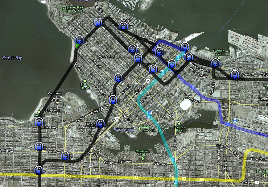
The core of its focus is what I am calling the BC line (which in this case simply means backwards ‘C’ ). This line is meant to improve the synergies between the 3 major existing lines and provide for better east-west and north-south trips. The thought experiments I followed to shape and design this line was to consider what it would be like to take transit between different municipalities and what could be added to reduce time or allow reasonable connectivity. Other fantasy lines here have had some sort of similar peninsular loop line that I have probably drawn from for inspiration but I think this is different enough. This network is meant to represent backbone transit, I assume that it is complemented by a Frequent transit network (FTN) that is primarily bus based. (There is of course space for streetcars or LRT where appropriate) Even though this is fantasy, I am trying to consider what would be practical and cost effective.

Summary: Primarily Bored tunnel that Travels from Kerrisdale (west boulevard & 41st) along 41s to Joyce where it continues over to Moscrop road. From there it curves North emerging from the ground to elevated rail travelling north along Willingdon. North of Brentwood it returns to tunnel, making a turn to the west to travel along Hasting until it reaches Waterfront Station. It is just over 23 km long and about 3 km would be above ground. (incidentally it divides neatly into two 10 km bored tunnels) It would take maybe about 40 mins to travel terminus to terminus although I figure that the average individual trip time on the line would be well under 15 mins.

Rationale & Thoughts:

Kerrisdale Terminus: I did not see a purpose to bring the line to ubc or to turn it north to intersect the UBC line. From Kerrisdale, UBC is already plenty accessible by bus (or even bike!) most other trips would be bound for somewhere east and then likely downtown. The short hop over to the Canada line fills this need handily. Similarly a northbound extension is not that useful as say UBC bound commuters on the BC line could easily transfer to the Canada Line before reaching Kerrisdale. Finally, it is conceivable that some sort of Streetcar/LRT that is part of some future false creek network might connect here.

Oak to Joyce: Most of what I thought about through here is where stations should be placed. The first impulse is to put stations at every intersection with a major north-south street, but then the stations are often too close together, not to mention that it just slows things down. I considered axing the oak st station, but there is this lovely large parcel of undeveloped land next to it (maybe there are plans for it already?). On oak the 17 bus also serves Women’s and Children’s hospital. Fraser I removed due to the proximity of both the graveyard and that it is quite close to Main. (I try to keep stop spacing over about 800 meters). There is no station between Rupert and Victoria due to crowding and also that there is no ‘good’ north-south street for a FTN connection.

Joyce Station Transfer station: This station would be tricky as there would be quite the vertical distance between platforms of the two lines. The station box would probably want to be built as close to the surface as possible. It’d like to think it is possible that an elevator could travel platform to platform .

Moscrop Station: I am tentative about the existence of this station and where exactly it should be situated. Boundary is too close to Joyce but Smith is not that much further either. There is then not another road that has reasonable north-south connectivity.

BCIT Station: I would stick with a single station to cover this area but then have some sort of heavily station integrated bike sharing network on the BCIT campus and other nearby IT sites like EA. I’d include some social engineering policy to prevent bike loss by having bikes returned to the station provide a ‘free’ transfer. (UBC Station should have similar treatment)

Brentwood Station: I would like to see more commercial office space around this station as it is a very central location in metro vancouver and even ‘close’ to the north shore (with a connecting north shore line). As all platforms are elevated there does not seem to be any major integration issues.

Brentwood to Boundary: I considered having a station near Willingdon and Hastings, but decided against it more for having too many stations then the difficulty of executing tight turns.

Boundary Station: This Station would have a connection to whatever system that the north shore uses (I have not thought too hard about the north shore yet although it is drawn). I imagine that there might be a system interchange for the train here, but I would think in normal operation you would not interline the trains due to frequency issues. I wonder what other people think about that though. We should also not presume that all north shore transferees are bound for downtown (Although a quick estimate suggested that taking the train all the way over here from Lonsdale and to downtown is about as fast as taking the Seabus and if the trains have reasonable frequency it would be a faster trip)

Boundary to Waterfront: This segment is not too hard to understand. Strathcona and Chinatown Stations are quite close. I positioned Strathcona closer to china town for two reasons. first above Glen drive the shore pinches in (so there is less area served by the station) and second, at Glen drive it would be surrounded by light industry. I feel that there is reason to preserve areas of light industry in the city and that a station in their midst would be a major pressure to redevelop.

Waterfront Station: Here is an open question: should it continue on/directly integrate into the expo line? Perhaps it might vary by the time of day? I also worry that having a super long line is less robust to disruption.

Here are some general thoughts about what this system addition does:

-Brings Richmond much closer to Burnaby and also Surrey. SFU is also closer (but with 4 transfers, hopefully the high frequency would make that tolerable and the 4th transfer would hopefully be hopping onto a Gondola )

-Brings the North Shore closer the Surrey and other eastern municipalities

-Connect BCIT into the network

-Improves the robustness of the overall network. If any of the segments towards downtown fails, there are still 2 other routes in and it is is possible to take the train to them.

Other Lines and that I drew:

Canada Line extension in Richmond: I think it would make more sense to terminate the Canada line at 3 road and Williams. Then all the buses is richmond can focus primarily on east-west routes that also serve as feeders to the Canada-line. A possible Streetcar could connect to steveston village from here.

Expo Line extension and ‘Surrey Line’: These are ideas that are completely borrowed from Translink that I just felt like drawing in. I have more thoughts about how white rock and langley might be integrated that I will perhaps develop on later.

North Shore Line: I do wonder if a line would render the sea bus obsolete. In which case I would bring the line under 3rd avenue and not bother directly connecting to the Quay. Lonsdale ave could use some sort of high frequency circulator, perhaps streetcars? (However where would you store and service them) East of Taylor way I feel that the Line is too close to the water to provide service efficiently, but there is no where else to run it. I certainly would not go further then 25st. It would be nice to serve Horseshoe bay but I think a shuttles running from the end of the line that is well timed with actual sailings would be more cost effective.

I hope this is at least an interesting thought experiment!

EDIT: Fixed calling Kerrisdale Dunbar...

Last edited by theho; Apr 19, 2012 at 4:35 PM.
Reply With Quote
     
     
This discussion thread continues

Use the page links to the lower-right to go to the next page for additional posts
 
 
Reply

Go Back   SkyscraperPage Forum > Regional Sections > Canada > Alberta & British Columbia > Vancouver > Transportation & Infrastructure
Forum Jump


Forum Jump


All times are GMT. The time now is 4:19 AM.

     
SkyscraperPage.com - Archive - Privacy Statement - Top

Powered by vBulletin® Version 3.8.7
Copyright ©2000 - 2024, vBulletin Solutions, Inc.