HomeDiagramsDatabaseMapsForum About
     

Go Back   SkyscraperPage Forum > Regional Sections > Canada > Atlantic Provinces > St. John's


Reply

 
Thread Tools Display Modes
     
     
  #221  
Old Posted Mar 1, 2013, 10:01 AM
mrjanejacobs's Avatar
mrjanejacobs mrjanejacobs is offline
Registered User
 
Join Date: Jan 2013
Location: Toronto
Posts: 460
I just toured the west-end area of the study area (not including the Oceanex parking) on Google street-view. This is a really cool couple blocks - I never properly appreciated it because it was/is such an undesirable area. I like how it's actually a couple blocks, somewhat gridded, narrow streets (historically scaled widths) that are not on a slope. There is a lot of potential in this area. What concerns me is a lack of planning. i don't think it's good enough to just have developers come in, one by one, building up on one parcel at a time. If they are just going to do this, then they might as well not do it at all, because it certainly won't do any favours for the livability of the area. We need urban design standards, landscape standards, public space standards - not to mention a comprehensive design strategy that will help integrate public transit, connectivity and other important elements for quality of life, like a policy requiring a minimum amount of tree planting and landscaping, not to mention a policy requiring that new buildings be built directly at the street front, unless an urban design argument can be made for creating a surface level plaza or something.

I would also propose that these buildings be maintained:


I say this just because I think they have a quality that is hyper St.John's-esque. It would be really neat to have a modern addition to the existing buildings or have some construction hover over or curiously cling to the side of these buildings. Plus small remnants of the past help maintain the character of the City. If we flatten the area - it will look like any other downtown - I don't think that is ok. I would much rather see our modern developments have a conversation with the historic buildings, rather than to antagonize or ostracize them. It doesn't have to be the this vs. that argument.
Reply With Quote
     
     
  #222  
Old Posted Mar 1, 2013, 10:05 AM
SignalHillHiker's Avatar
SignalHillHiker SignalHillHiker is online now
I ♣ Baby Seals
 
Join Date: Jul 2012
Location: Sin Jaaawnz, Newf'nland
Posts: 34,725
Well, the City Planner is retiring so it's a great time to send a letter to the city with your fantastic suggestions.
__________________
Note to self: "The plural of anecdote is not evidence."
Reply With Quote
     
     
  #223  
Old Posted Mar 1, 2013, 10:11 AM
mrjanejacobs's Avatar
mrjanejacobs mrjanejacobs is offline
Registered User
 
Join Date: Jan 2013
Location: Toronto
Posts: 460
haha - yeah, I heard about that

What do we know about him? I know noting. Was he not a good planner? Or was his department just under funded and disempowered?

I would also be interested in promoting a lobby group to bring a more focused attention to planning and urban design in the City with a more robust planning department with more power.
Reply With Quote
     
     
  #224  
Old Posted Mar 1, 2013, 11:03 AM
SignalHillHiker's Avatar
SignalHillHiker SignalHillHiker is online now
I ♣ Baby Seals
 
Join Date: Jul 2012
Location: Sin Jaaawnz, Newf'nland
Posts: 34,725
I get the impression he was a bit hamstrung by the anti-development sentiment that seems to be the loudest voice related to development in the city. But I don't know him, so... who knows.
__________________
Note to self: "The plural of anecdote is not evidence."
Reply With Quote
     
     
  #225  
Old Posted Mar 1, 2013, 2:49 PM
Ayreonaut's Avatar
Ayreonaut Ayreonaut is offline
EVDS MPlan Grad
 
Join Date: Nov 2007
Location: Canmore, AB
Posts: 11,980
I agree that if anything is to be done there, it should be masterplanned. Developing areas bit by bit rarely results in the same level of cohesiveness.

Quote:
Originally Posted by AnUrbanLife View Post
I would love to see that area, Oceanex parking lot, turned into a type of Amsterdam Canal street, with mid and high rise development on both sides of the waterford.

That IMHO would be amazing!
It could be our very own Aker Brygge, which is on reclaimed industrial land on Oslo's port.
Reply With Quote
     
     
  #226  
Old Posted Mar 1, 2013, 2:52 PM
SignalHillHiker's Avatar
SignalHillHiker SignalHillHiker is online now
I ♣ Baby Seals
 
Join Date: Jul 2012
Location: Sin Jaaawnz, Newf'nland
Posts: 34,725
If I ever earn/win a billion, I'm doing it. I wish I had the money to take a large area like this and do proper urban planning - like Pleasantville.
__________________
Note to self: "The plural of anecdote is not evidence."
Reply With Quote
     
     
  #227  
Old Posted Mar 1, 2013, 2:53 PM
Ayreonaut's Avatar
Ayreonaut Ayreonaut is offline
EVDS MPlan Grad
 
Join Date: Nov 2007
Location: Canmore, AB
Posts: 11,980
I might be getting there. I've won Lotto Max three weeks in a row now! Just a free ticket each time, but still (I usually buy a ticket every three or four months, but they keep giving me a new one!).
Reply With Quote
     
     
  #228  
Old Posted Mar 2, 2013, 1:50 AM
jeddy1989's Avatar
jeddy1989 jeddy1989 is offline
Registered User
 
Join Date: Dec 2009
Location: St. John's, NL
Posts: 2,711
If we bring back the street cars DT do you think we should have modern style street cars there or vintage street cars like in San Francisco ?


Photo by Jim Steinhart
http://travelphotobase.com/v/F/FST233.HTM


Posted by Chris Bateman
http://www.blogto.com/city/2012/09/s...sam_sniderman/

OR


https://sites.google.com/a/ironmail....r-day-bellwork

from Prtland

http://trimet.org/schedules/trolley.htm

Obviously the modern ones would be better for residents, however maybe we could have the modern ones and then have one old one that we put on doing the loops during the spring and summer for a tourist attraction (it could be very nice)
__________________
-Where Once They Stood-
-We Stand-
Reply With Quote
     
     
  #229  
Old Posted Mar 2, 2013, 1:57 AM
SignalHillHiker's Avatar
SignalHillHiker SignalHillHiker is online now
I ♣ Baby Seals
 
Join Date: Jul 2012
Location: Sin Jaaawnz, Newf'nland
Posts: 34,725
I'd be happy with (and use, religiously) either.
__________________
Note to self: "The plural of anecdote is not evidence."
Reply With Quote
     
     
  #230  
Old Posted Mar 2, 2013, 2:05 AM
Architype's Avatar
Architype Architype is offline
♒︎ Empirically Canadian
 
Join Date: Mar 2004
Location: 🍁 Canada
Posts: 11,998
I think an LRT system, or even a streetcar system should be fairly simple to implement in St. John's because of the linear pattern of development. To me it seems fairly simple to plan out a route which would begin at MUN, go East to Torbay Road, skirt Pleasantville, and then proceed through downtown, ending somewhere on Topsail Road probably around the Village Mall or even as far as Mt.Pearl, with future extensions planned to go much farther, possibly including a complete circle. Along this route there would be designated high density growth areas, commonly known as transit oriented development (TOD).
Reply With Quote
     
     
  #231  
Old Posted Mar 2, 2013, 2:12 AM
jeddy1989's Avatar
jeddy1989 jeddy1989 is offline
Registered User
 
Join Date: Dec 2009
Location: St. John's, NL
Posts: 2,711
Quote:
Originally Posted by Architype View Post
I think an LRT system, or even a streetcar system should be fairly simple to implement in St. John's because of the linear pattern of development. To me it seems fairly simple to plan out a route which would begin at MUN, go East to Torbay Road, skirt Pleasantville, and then proceed through downtown, ending somewhere on Topsail Road probably around the Village Mall or even as far as Mt.Pearl, with future extensions planned to go much farther, possibly including a complete circle. Along this route there would be designated high density growth areas, known as transit oriented development (TOD).
downtown the cost wouldn't even be as high because the old tracks are still there just under the pavement and show up sometimes in the spring.

I think starting with loops mainly downtown would be good even using the old tracks, then looking at lines further out (of course utilizing my transit system overhaul design )

I believe (of course including a complete overhaul of the current bus route system) we need to implement street cars again even if it is just downtown at first

eventually like you said we could use them as a part of a bigger system and even a commuter light rail line coming from CBS (probably from their hub in their DT)
__________________
-Where Once They Stood-
-We Stand-
Reply With Quote
     
     
  #232  
Old Posted Mar 2, 2013, 2:21 AM
Architype's Avatar
Architype Architype is offline
♒︎ Empirically Canadian
 
Join Date: Mar 2004
Location: 🍁 Canada
Posts: 11,998
Quote:
Originally Posted by jeddy1989 View Post
downtown the cost wouldn't even be as high because the old tracks are still there just under the pavement and show up sometimes in the spring.
I really don't think they could still use the old tracks if that's what you meant.
Can you give a link to the system map you did?
Reply With Quote
     
     
  #233  
Old Posted Mar 2, 2013, 2:28 AM
jeddy1989's Avatar
jeddy1989 jeddy1989 is offline
Registered User
 
Join Date: Dec 2009
Location: St. John's, NL
Posts: 2,711
Quote:
Originally Posted by Architype View Post
I really don't think they could still use the old tracks if that's what you meant.
Can you give a link to the system map you did?
yeah they probably would need to upgrade them lol

yeah here's the link

remember it's just a concept

ok so here it goes... here is the transit system I came up with ..

I havent added mount pearl yet or the Goulds.. I think the goulds could use the same routes as it does now, but it may need a more creative solution.

anyways here goes nothing

explanation:

The system is a feeder/hub/express system.

This is inspired by how subway systems work in unisen with buses.
Buses gather people to subwaystations which then take people to points of interest rapidly.

The basics of the system is that there are hubs which have bus terminals and desired destinations with many people.
then the hubs are connected by express routes which go non stop between the major points of interests.
gathering people from the streets to the hubs are feeder routes which are the winding routes we are more use to, however they are short and the buses run both ways on them.
This makes the winding trips no longer than 15 minutes (the route could take 30 minutes to complete the loop to the hub however the max is 15 minutes either way.

The timing is what makes this efficient. if it takes you 10 minutes on the feeder then you arrive at the hub (all routes will be times to arrive when the express routes will depart)
then you get an express to the hub desired. this will take about 20 minutes give or take.
Then if you desire to venture further from the destination hub by taking one of it's feeders, it will only take a max of 15 minutes more.

what makes this efficient is the combination of feeder routes bringing people to and from the hubs and express routes rushing people between hubs.

reducing transfers

To reduce the amount of transfers, some of the buses could continue whilst changing route. for example take the D1 bus to hub D then that bus will become the bus which goes on the express route to hub C from there.
When it gets to hub C it continues as a C1 route bus. Of course an announcement will be made when they change route, and this will be a consistent practice for paired up routes.
Most people will most likely get off at a hub however this gives the opportunity to reduce the amount of transfers on a journey.
In theory a person could take a bus from kenmount terrace to the Avalon mall which then goes directly to the Village mall and continues on to the west end to for example Bowring park in about 30-35 minutes.
This is a dramatic increase in efficiency compared to the current system.

Expanding the system

This style of system allows easy additions. for example mount pearl could add a Hub or two and a few short feeder routes which serve the needs of the community then connect them with the existing system via express routes.
Assuming not all communities come on line in the region right away, in order to reduce the amount of traffic,
park and ride can be established at the hubs which will have express routes and no worries of parking to the areas of interest such as downtown.
Places such as CBS can eventually connect their hub(s) via express routes using the highway (very fast access to downtown).

Another upgrade to infrastructure I would suggest eventually happen is that the main through fares such as colombus drive add a bus/carpool lane. This will give transit an added advantage over
cars and make it more desirable while allowing a more efficient system during peek hours. As well, emergency vehicules can use these lanes to bypass most traffic.


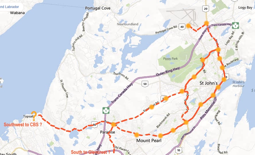
here is a simplified map .. so you can see how there are feeders and express routes connecting.


to explain the route numbering

The Hubs are lettered A,B,C,D,E,F and their feeder routes are their letter plus a number ex. B2

The express routes are lettered with Z and are grey

Black routes are for when more than 2 routes take the same road (to reduce the number of lines)


Here is the system map:

__________________
-Where Once They Stood-
-We Stand-
Reply With Quote
     
     
  #234  
Old Posted Mar 2, 2013, 2:39 AM
Architype's Avatar
Architype Architype is offline
♒︎ Empirically Canadian
 
Join Date: Mar 2004
Location: 🍁 Canada
Posts: 11,998
^ Thanks for posting that. I will confess I'm not too familiar with the present system, but whenever I've seen a map or asked questions about it, it all seems to make little sense, as the bus routes all seem convoluted and never seem to go where you would want to go.
Reply With Quote
     
     
  #235  
Old Posted Mar 2, 2013, 2:40 AM
AnUrbanLife's Avatar
AnUrbanLife AnUrbanLife is offline
Registered User
 
Join Date: Dec 2012
Posts: 146
Quote:
Originally Posted by Ayreonaut View Post
I agree that if anything is to be done there, it should be masterplanned. Developing areas bit by bit rarely results in the same level of cohesiveness.


It could be our very own Aker Brygge, which is on reclaimed industrial land on Oslo's port.


Yeah I'm a big fan of Aker Brygge, a gem of liveable urban design that makes the pedestrian king, which I love.
Reply With Quote
     
     
  #236  
Old Posted Mar 2, 2013, 2:50 AM
jeddy1989's Avatar
jeddy1989 jeddy1989 is offline
Registered User
 
Join Date: Dec 2009
Location: St. John's, NL
Posts: 2,711
Quote:
Originally Posted by Architype View Post
^ Thanks for posting that. I will confess I'm not too familiar with the present system, but whenever I've seen a map or asked questions about it, it all seems to make little sense, as the bus routes all seem convoluted and never seem to go where you would want to go.
that's the problem, they do not know what to do because our city is not on a grid.. they try to hit various major points and pick everyone up on the way which causes a very inconvenient system when the city is laid out like ours and people cant just walk a block or two over to hop on the bus because there aren't really any actual blocks lol

they also are struggling because they are loosing money so they don't increase service but that causes even lower ridership and then you have the regional problem where the other municipalities obviously do not want to connect into this system and with all the traffic from the suburbs causing metrobus to be even more inefficient but noone wanting to flip the bill and it's all a mess.. I can assure you that councilors recognize this and are just entrusting metrobus to figure it out and I think they just need some fresh ideas. One that I have even talked to about this, is the mayor and it's a big issue that they are trying to solve it.. he is very aware of it's importance and it's just figuring out the path to get there.they have done things to try to help like all the programs like air miles, the WiFi and the new bus depot out next to kelsey drive to be in the centre of the metro area for future expansion and they really want a regional system but are facing the fractured region problem. they are doing those things but they just seem to miss the essential problem with the routes

here is the current system:

http://www.metrobustransit.ca/systemmap.asp#anchor
__________________
-Where Once They Stood-
-We Stand-
Reply With Quote
     
     
  #237  
Old Posted Mar 2, 2013, 3:26 AM
Architype's Avatar
Architype Architype is offline
♒︎ Empirically Canadian
 
Join Date: Mar 2004
Location: 🍁 Canada
Posts: 11,998
Here's how I would design a modern transit system for St. John's, just a basic route without any confusion. I'm not sure what type of system it would be but some kind of LRT system should work along these routes. Of course, the bus system woud work to fill in gaps in conjunction with this, but far fewer bus routes would be required.

The solid line represents phase one, and the dashed lines future extensions, the orange dots are stations, some of which would have high density mixed use development zones around them:

Reply With Quote
     
     
  #238  
Old Posted Mar 2, 2013, 3:48 AM
jeddy1989's Avatar
jeddy1989 jeddy1989 is offline
Registered User
 
Join Date: Dec 2009
Location: St. John's, NL
Posts: 2,711
Quote:
Originally Posted by Architype View Post
Here's how I would design a modern transit system for St. John's, just a basic route without any confusion. I'm not sure what type of system it would be but some kind of LRT system should work along these routes. Of course, the bus system woud work to fill in gaps in conjunction with this, but far fewer bus routes would be required.

The solid line represents phase one, and the dashed lines future extensions, the orange dots are stations, some of which would have high density mixed use development zones around them:

yes I agree, I think we will eventually move into that when the population is larger.

I think currently we need to work with what we have in terms of the bus system and maybe introducing the street cars. HOWEVER I completely agree with that and being such a linear city a subway system would be AWESOME however that wont happen even if we had the population, due to the rock. Therefore most likely LRT or some sort of rapid transit (I'd love to see a monorail hehe but that's kind of a fantasy)

I'm excited by the transit talk because if I get into council this will be a MAJOR thing I will push for improving dramatically
__________________
-Where Once They Stood-
-We Stand-
Reply With Quote
     
     
  #239  
Old Posted Mar 2, 2013, 3:53 AM
Architype's Avatar
Architype Architype is offline
♒︎ Empirically Canadian
 
Join Date: Mar 2004
Location: 🍁 Canada
Posts: 11,998
I wonder if there is even a bus route which follows along these strightforward lines? Even that might be helpful, because in a small city like St. John's you should not even have to transfer between routes to get from one major destination to another, it should be easy, regular and intuitive.
Reply With Quote
     
     
  #240  
Old Posted Mar 2, 2013, 3:59 AM
jeddy1989's Avatar
jeddy1989 jeddy1989 is offline
Registered User
 
Join Date: Dec 2009
Location: St. John's, NL
Posts: 2,711
Quote:
Originally Posted by Architype View Post
I wonder if there is even a bus route which follows along these strightforward lines? Even that might be helpful, because in a small city like St. John's you should not even have to transfer between routes to get from one major destination to another, it should be easy, regular and intuitive.
I agree, that's why I think there should be non stop express routes between major points, and feeder routes to bring people to the major points (the frequency of the feeder routes could be adjusted based on the ridership of the area or have smaller/larger buses without affecting the other routes) that's basically what the system I came up with is.. and it is very simple just looks confusing when you at it all together

you have a hub which connects to the other hubs via express routes in a very frequent and rapid way .. then you have feeder routes to and from the hubs to the surrounding areas
__________________
-Where Once They Stood-
-We Stand-
Reply With Quote
     
     
This discussion thread continues

Use the page links to the lower-right to go to the next page for additional posts
 
 
Reply

Go Back   SkyscraperPage Forum > Regional Sections > Canada > Atlantic Provinces > St. John's
Forum Jump


Forum Jump


All times are GMT. The time now is 5:02 PM.

     
SkyscraperPage.com - Archive - Privacy Statement - Top

Powered by vBulletin® Version 3.8.7
Copyright ©2000 - 2024, vBulletin Solutions, Inc.