HomeDiagramsDatabaseMapsForum About
     

Go Back   SkyscraperPage Forum > Regional Sections > Canada > Ontario > Ottawa-Gatineau > Culture, Dining, Sports & Recreation


Reply

 
Thread Tools Display Modes
     
     
  #221  
Old Posted Feb 18, 2015, 3:42 PM
Kitchissippi's Avatar
Kitchissippi Kitchissippi is offline
Busy Beaver
 
Join Date: Nov 2005
Location: Ottawa
Posts: 4,364
Speaking of fountains, they have this cool hydraulophone at the Ontario Science Centre. We should have one of these somewhere downtown so someone can jam with the Peace Tower carillon
Video Link


The inventor is this brilliant prof from UofT

Video Link


I bet if they replaced the unremarkable fountain behind the Supreme Court with one of these it would actually draw people out there more than the proposed monument to the victims of communism....
Reply With Quote
     
     
  #222  
Old Posted Feb 19, 2015, 5:36 AM
Catenary Catenary is offline
Registered User
 
Join Date: Dec 2012
Posts: 1,307
Quote:
Originally Posted by Buggys View Post
Too much maintenance for our cold winters.
There's a fountain in my hometown. In winter, it's drained, and then shrink wrapped like a boat. I would think a modern fountain could be built to not require shrink wrapping, so the only issue would be draining it. Not having to operate it for 6 months of the year probably helps keep hydro costs down and increase pump longevity.
Reply With Quote
     
     
  #223  
Old Posted Feb 19, 2015, 11:50 AM
Buggys Buggys is offline
Registered User
 
Join Date: Dec 2012
Location: Ottawa
Posts: 659
Quote:
Originally Posted by Catenary View Post
There's a fountain in my hometown. In winter, it's drained, and then shrink wrapped like a boat. I would think a modern fountain could be built to not require shrink wrapping, so the only issue would be draining it. Not having to operate it for 6 months of the year probably helps keep hydro costs down and increase pump longevity.
The shrink wrap is probably additional assurance that snowfall would not turn into ice in the open pipes of the fountain, which would expand and potentially crack up mechanisms inside the fountain. Not sure that we have a miracle workaround for that.

Someone has to pay for this maintenance work, and I don't want it to come from my taxes. If a private mall owner wants to put one in with their own $, fine.
Reply With Quote
     
     
  #224  
Old Posted Feb 19, 2015, 3:20 PM
phil235's Avatar
phil235 phil235 is online now
Registered User
 
Join Date: Sep 2006
Location: Ottawa
Posts: 3,764
Quote:
Originally Posted by Buggys View Post
The shrink wrap is probably additional assurance that snowfall would not turn into ice in the open pipes of the fountain, which would expand and potentially crack up mechanisms inside the fountain. Not sure that we have a miracle workaround for that.

Someone has to pay for this maintenance work, and I don't want it to come from my taxes. If a private mall owner wants to put one in with their own $, fine.
Isn't a fountain just like any other public realm improvement. Don't they all require maintenance? Not sure why it would be any less worthy of your tax dollars than other aesthetic improvements.

Montreal has plenty of public fountains and they seem to make it work in this climate. A couple of the best new public squares in Montreal are designed around fountains, and they make a huge difference to the areas they are in.
Reply With Quote
     
     
  #225  
Old Posted Mar 27, 2015, 5:40 PM
passwordisnt123 passwordisnt123 is offline
Registered User
 
Join Date: Mar 2015
Location: Ottawa (Centretown)
Posts: 626
Hi everybody,

I've been a lurker on this forum for several years and I finally decided to make my first post.

I really loved the Google Earth mockups that defishel did earlier in this thread. They got me thinking about the challenge of designing an optimal zoning scheme for downtown/centretown that would both a) maximize TOD near the two Confederation Line stations and b) provide something of an "exclusion zone" around the Peace Tower to maximize views of the tower without resorting to the rigidly uniform building height scheme that is currently favoured by the NCC north of Laurier.

I recognize this is somewhat pie-in-the-sky since a lot of this land is NCC land, but I designed a mathematical model that I think would find the optimal compromise between the competing (and sometimes contradictory) goals of TOD around the LRT stations and maximizing views of Parliament.


For those math nerds on the forum, the two maps combine a series of three dimensional trigonometric curves and then “slices off” (for lack of a better word) an exclusion zone centred around the Peace Tower defined as:

The smaller number between x/4 and 180 metres in height

Whereas “x” is the two-dimensional distance in meters from any given point on the map and the centre of the Peace Tower.

The curves defining the building heights on the map are defined as:

(2a+b)/3

Whereas “a” is a series of three-dimensional cosine curve segments centred around the three Confederation Line stations (Lyon, Parliament and uOttawa) and “b” represents a three-dimensional sine curve centred around the Peace Tower.

Under this scheme, areas of the map with no shading would retain their existing zoning regulations, whatever those may be.
Reply With Quote
     
     
  #226  
Old Posted Mar 27, 2015, 5:56 PM
MoreTrains MoreTrains is offline
Registered User
 
Join Date: Oct 2014
Posts: 858
This is a pretty interesting proposition. I do believe the majority of TOD the city is looking at is locate outside of downtown, but if there were increases downtown there would be a greater benefit, such as the probable revitalization of Sparks with the additional population. Especially given these locations are more conducive to walking than driving, the foot traffic through the area would greatly increase which would be highly beneficial to the businesses in the area outside of the 9-5 government work day.
But alas, despite the government owned buildings there already, I am pretty sure the NCC would have a fit, especially in the 180m area.
Reply With Quote
     
     
  #227  
Old Posted Jul 22, 2015, 2:55 PM
Arcologist Arcologist is offline
Registered User
 
Join Date: Oct 2011
Location: The Nation's Capital
Posts: 687
Interesting stuff, thanks for sharing!
Reply With Quote
     
     
  #228  
Old Posted Jul 22, 2015, 3:51 PM
passwordisnt123 passwordisnt123 is offline
Registered User
 
Join Date: Mar 2015
Location: Ottawa (Centretown)
Posts: 626
Quote:
Originally Posted by Arcologist View Post
Interesting stuff, thanks for sharing!
Thanks!
Reply With Quote
     
     
  #229  
Old Posted Aug 19, 2016, 5:37 PM
rocketphish's Avatar
rocketphish rocketphish is offline
Planet Ottawa and beyond
 
Join Date: Feb 2009
Location: Ottawa
Posts: 12,321
6 ways the city of Ottawa is reconnecting with its river

Don Butler, Ottawa Citizen
Published on: August 19, 2016 | Last Updated: August 19, 2016 10:30 AM EDT


LeBreton Flats

Since its proposal was rated highest in a competition earlier this year, Eugene Melnyk’s RendezVous LeBreton team has been trying to negotiate a development agreement with the NCC. If its plan proceeds, 7,000 people will call LeBreton Flats home — as many as lived there in the early 1900s — by the time the final phase is complete, two decades from now. Another 12,000 could work there.

While a “major event centre” is the centrepiece of the RendezVous plan, other elements would connect to and expand existing federal park space along the river. The result would be a continuous public realm from the Nepean Bay inlet, where a boardwalk would extend over the water, along a heritage aqueduct lined with cafés and shops to the Fleet Street Pumping Station tailrace, then out to and along the river.

Further west, in the final-phase Bayview neighbourhood, the Place de la Gare boardwalk would connect pedestrians to the Ottawa River pathway system and a new “Waterfront Promenade.”

Zibi

The $1.2-billion development spans 37 acres near Chaudière Falls. When completed around 2025, there will be 1,200 condo apartments, retail and office space and new parkland on two Ottawa River islands and the Gatineau waterfront.

There will be public access to the water everywhere except where four preserved heritage buildings are tight to the waterline. “Other than those, the entire waterfront is publicly accessible,” says Jeff Westeinde, executive chairman of the Windmill Development Group. As part of the development, the east and west ends of Chaudière Island will become “sunrise and sunset” parks.

“We hope to create something like a Granville Island in Vancouver, plus a really interesting mix of arts, culture, industry as well as tourism and entertainment,” Westeinde says. “We have the opportunity to do that for Ottawa.”

Sir John A. Macdonald Linear Park

While it could take as long as two decades to fully develop the nine-kilometre riverfront park between LeBreton Flats and the Mud Lake Conservation Area, the NCC plans to create four “animation nodes” in the short-to-medium term.

At two connected nodes, called Westboro Beach and Atlantis, there will be improvements to the facilities at the beach, offering such things as a rental and repair shop for kayaks, skis, snowshoes and bicycles, as well as a small restaurant. The adjacent Atlantis site could be transformed into a conservation centre.

At another node, Rochester Field, the NCC aims to create safe and enhanced access across the parkway to the river and a new shoreline lookout. Up to two-thirds of Rochester Field could be made available for development. The rest will be parkland that will include a central water feature and a history loop with public art and interpretation.

The other short-to-medium-term node would be the Deschênes area. The NCC is planning a pricey boardwalk, partly over the water, that would include a viewing tower, lookout and public art. In the longer term, the NCC wants other animation nodes at Remic Rapids, near Parkdale Avenue and around the Champlain Bridge. An equivalent, yet-unnamed linear park is also in the works for the Quebec shore of the river.
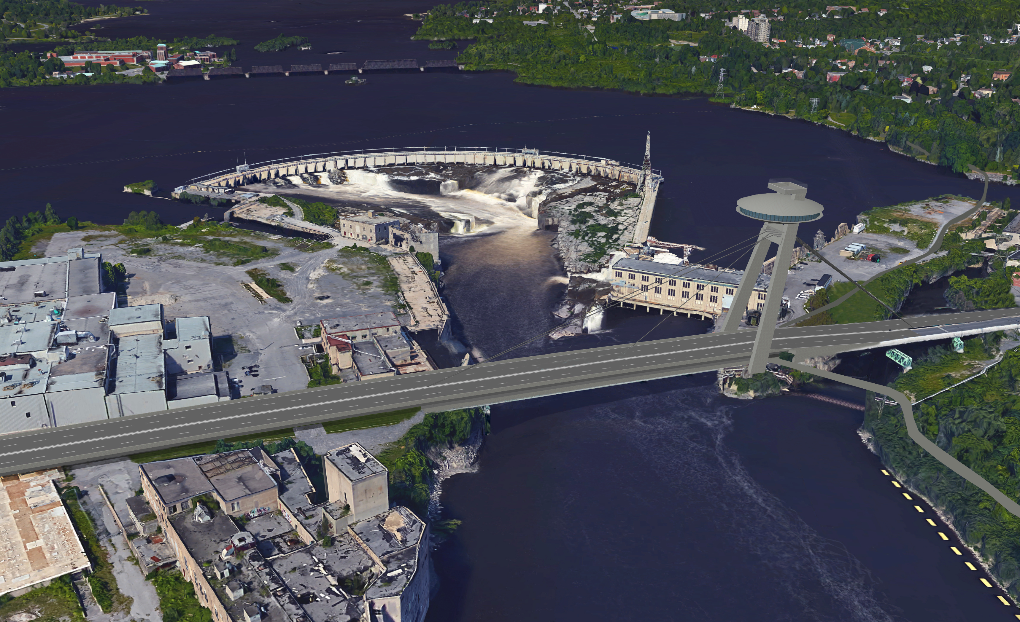
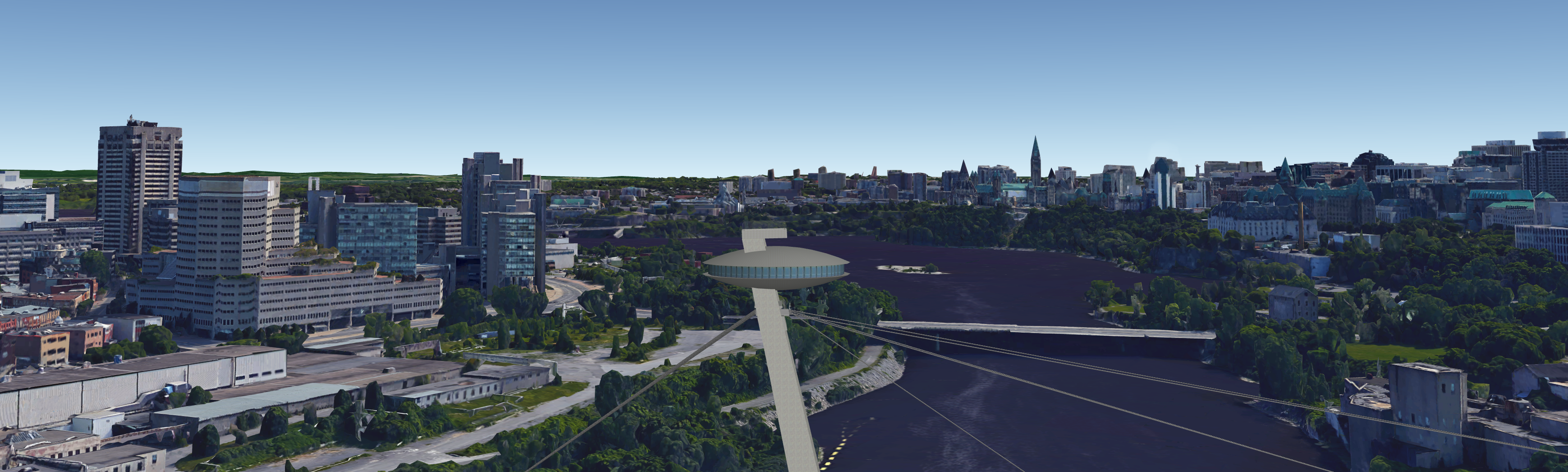
Chaudière Falls

Ottawa Hydro is spending $150 million to build a new 29-megawatt hydroelectric generating facility below grade at Chaudière Falls. It will feature three viewing platforms atop the generating station and a new bridge for pedestrians and cyclists across the intake channel.

Once the station opens in 2017, people will be able to walk or bike to view the falls, long hidden from public sight. Hydro also wants an interpretive centre highlighting green energy and the historical significance of the site for indigenous peoples, says president and CEO Bryce Conrad.

“We recognize that we’re the custodians of this asset in the near future, and we recognize it as being a responsibility,” Conrad says. “Part of that responsibility is to honour and remember the aboriginal heritage that’s down there, as well as to open up this facility and this area for the citizens of Gatineau and Ottawa so they can actually see this magnificent space and magnificent vista.”

Richmond Landing and the pulp mill ruins

The NCC has already begun to improve access to Richmond Landing — the site of a small settlement in 1808, even before the founding of Bytown — and the nearby Bronson Pulp Mill ruins, just west of the Mill Street Brew Pub. The first phase of the project is underway, and at least some elements will be finished in time for the 2017 sesquicentennial.

Bridges will connect Richmond Landing, Victoria Island and Amelia Island to provide access for pedestrians and cyclists. The NCC will also provide universally accessible routes from Wellington Street at the Portage Bridge to Richmond Landing and the pulp mill ruins.

Interpretive elements in the area — which the NCC calls one of the capital’s hidden treasures — will also highlight the aboriginal and natural heritage of the islands, recognize the area’s military past and showcase the manufacturing and power generation industries that helped build Ottawa. The goal, according to NCC officials, is to create a site of national significance.

North shore park improvements

The NCC plans to improve existing riverfront parks in Gatineau, including Jacques Cartier Park, and add new parkland and connections on all federally owned land bordering the river shore in downtown Gatineau, including both mouths of Brewery Creek. The intent is to make the shoreline more accessible and increase the appeal of the riverfront parks.

Among other things, the plan will transform an existing parking area near the Kruger plant into a shoreline park, develop a boat launch for non-motorized watercraft, create a recreational pathway around Ile-de-Hull and develop Scott Point as a panoramic lookout. A draft implementation plan should be completed this summer, with public consultations in the fall and final approval in January by the NCC’s board of directors.

dbutler@postmedia.com
twitter.com/ButlerDon

http://ottawacitizen.com/news/local-...with-its-river
Reply With Quote
     
     
  #230  
Old Posted Aug 19, 2016, 7:07 PM
Uhuniau Uhuniau is offline
Registered User
 
Join Date: Jan 2010
Posts: 8,032
Quote:
Originally Posted by passwordisnt123 View Post
Hi everybody,

I've been a lurker on this forum for several years and I finally decided to make my first post.

Welcome - and wow!
__________________
___
Enjoy my taxes, Orleans (and Kanata?).
Reply With Quote
     
     
  #231  
Old Posted Aug 19, 2016, 7:25 PM
Uhuniau Uhuniau is offline
Registered User
 
Join Date: Jan 2010
Posts: 8,032
Quote:
Originally Posted by rocketphish View Post
6 ways the city of Ottawa is reconnecting with its river

Don Butler, Ottawa Citizen
Published on: August 19, 2016 | Last Updated: August 19, 2016 10:30 AM EDT
East end seems to be chopped liver again. No improved access or animation downstream?
__________________
___
Enjoy my taxes, Orleans (and Kanata?).
Reply With Quote
     
     
  #232  
Old Posted Jul 7, 2017, 6:32 PM
lrt's friend lrt's friend is offline
Registered User
 
Join Date: Dec 2006
Posts: 11,865
I was in Montreal on Monday and I was impressed that they are making the Old Port area fun for all ages. They had built a children's play area (not just a playground), an area with more challenging activities for teenagers, zip lines and a giant permanent Ferris wheel is nearing completion.

Why is Ottawa not doing something like this?
Reply With Quote
     
     
  #233  
Old Posted Jul 11, 2017, 7:41 PM
J.OT13's Avatar
J.OT13 J.OT13 is offline
Moderator
 
Join Date: Mar 2012
Location: Ottawa
Posts: 24,011
We had a golden opportunity with Lansdowne, but alas, the city cheaped out.

I won't get my hopes up, but maybe LeBreton Flats...
Reply With Quote
     
     
  #234  
Old Posted Apr 4, 2018, 3:35 AM
Kitchissippi's Avatar
Kitchissippi Kitchissippi is offline
Busy Beaver
 
Join Date: Nov 2005
Location: Ottawa
Posts: 4,364
A total rip-off of Bratislava's SNP bridge, but replacing the Chaudière Bridge with a new cable stayed structure avec observatoire would be pretty neat. A two-level bridge with a lower level just for pedestrians and cyclists (maybe glassed in?). The vehicular deck could be built higher than existing to facilitate internal pedestrian circulation within the islands. Another revolving restaurant, perhaps?

Just experimenting with placing 3D models in Google Earth


click go big

Reply With Quote
     
     
  #235  
Old Posted Apr 4, 2018, 1:55 PM
Richard Eade Richard Eade is offline
Registered User
 
Join Date: Mar 2008
Location: Nepean
Posts: 1,952
I like this idea. And charging a nominal fee for tower access (included in the meal/bar tab? or as an elevator 'toll'?) could help off-set the bridge’s maintenance costs.

However, can we direct the bridge to a more useful place in Gatineau?


I would also like to see a bi-level bridge used for the O-Train – Trillium Line over the Rideau River. The train on the upper deck and a MUP, with extending viewing/sitting areas cantilevered out the sides, for the lower deck.
Reply With Quote
     
     
  #236  
Old Posted Apr 4, 2018, 2:25 PM
User Name User Name is offline
BANNED
 
Join Date: Nov 2017
Posts: 32
A bigger, better impact on the city would be in replacing the old, ugly Alexandra Bridge with a nice new suspension bridge.
Reply With Quote
     
     
  #237  
Old Posted Apr 4, 2018, 3:29 PM
Uhuniau Uhuniau is offline
Registered User
 
Join Date: Jan 2010
Posts: 8,032
Quote:
Originally Posted by User Name View Post
A bigger, better impact on the city would be in replacing the old, ugly Alexandra Bridge with a nice new suspension bridge.
What's ugly about the Alexandra Bridge?
__________________
___
Enjoy my taxes, Orleans (and Kanata?).
Reply With Quote
     
     
  #238  
Old Posted Apr 4, 2018, 3:38 PM
lrt's friend lrt's friend is offline
Registered User
 
Join Date: Dec 2006
Posts: 11,865
Quote:
Originally Posted by Uhuniau View Post
What's ugly about the Alexandra Bridge?
Beauty is in the eye of the beholder, but I personally agree that I like the Alexandra Bridge. Far better than the MacDonald-Cartier bridge, a bland highway bridge if I ever saw one.

If any bridge needs to be replaced with something more attractive, it is the Queensway bridge over the Rideau Canal.
Reply With Quote
     
     
  #239  
Old Posted Apr 4, 2018, 4:17 PM
Aylmer's Avatar
Aylmer Aylmer is offline
Still optimistic
 
Join Date: Nov 2007
Location: Montreal (C-D-N) / Ottawa (Aylmer)
Posts: 5,383
The Alexandra Bridge does need to be replaced though. The people I've talked to at PWGSC said that the current reno efforts will extend its life til about 15 years from now, but at that point it will either have to undergo a complete structural reconstruction or just total reconstruction.

I'd love to see a rebuilt Alexandra with two decks: a lower deck for Gatineau LRT headed towards Ottawa, and an upper deck dedicated to people on foot and bike. You could have greenery and landscaping, turning the bridge into an extension of Major's Hill Park and Jacques Cartier Park.

The loss of traffic capacity by removing cars would be marginal, since it's only two lanes out of 20 crossing the river. I'd even wager that by removing the Alexandra/Sussex/Mackenzie/St Patrick/Murray clusterfuck by the National Art Gallery, you'd actually speed up traffic.
__________________
I've always struggled with reality. And I'm pleased to say that I won.
Reply With Quote
     
     
  #240  
Old Posted Apr 4, 2018, 5:21 PM
User Name User Name is offline
BANNED
 
Join Date: Nov 2017
Posts: 32
Quote:
Originally Posted by Uhuniau View Post
What's ugly about the Alexandra Bridge?
It’s an old rail bridge with some functionality issues. It’s location is PRIME for a prominent landmark bridge. Old rail bridges are a dime a dozen. Doesn’t exactly make a “world class” statement
Reply With Quote
     
     
This discussion thread continues

Use the page links to the lower-right to go to the next page for additional posts
 
 
Reply

Go Back   SkyscraperPage Forum > Regional Sections > Canada > Ontario > Ottawa-Gatineau > Culture, Dining, Sports & Recreation
Forum Jump


Forum Jump


All times are GMT. The time now is 10:57 AM.

     
SkyscraperPage.com - Archive - Privacy Statement - Top

Powered by vBulletin® Version 3.8.7
Copyright ©2000 - 2024, vBulletin Solutions, Inc.