HomeDiagramsDatabaseMapsForum About
     

Go Back   SkyscraperPage Forum > Discussion Forums > Transportation


Reply

 
Thread Tools Display Modes
     
     
  #21  
Old Posted Mar 31, 2009, 6:48 AM
BTinSF BTinSF is offline
BANNED
 
Join Date: Jun 2006
Location: San Francisco & Tucson
Posts: 24,088
San Francisco Bay Area

Interestingly, this doesn't include the cable car system or the historic trolleys--only the lines using modern rolling stock


Source: http://www.urbanrail.net/am/snfr/sf-bay-area-map.htm

This is a detail of Muni Metro (also showing only the lines using modern equipment)--shown as solid red lines in the map above


Source: http://transit.511.org/static/provid...2200722845.gif

Here's the cable cars:


Source: http://www.sfcablecar.com/rout1.html

Last edited by BTinSF; Mar 31, 2009 at 7:04 AM.
Reply With Quote
     
     
  #22  
Old Posted Mar 31, 2009, 10:57 AM
Lear's Avatar
Lear Lear is offline
Registered User
 
Join Date: Oct 2008
Location: Europa
Posts: 917
Berlin Rail and Metro

Berlin combines 3 very large urban Metro/Rail networks which are tightly interwoven. Taken together, these systems form the largest inner city rail system in Europe and most likely one of the largest in the world.

The 2 Metro systems (only colored lines) on this map include the S-Bahn (mainly overground) and the U-Bahn (undergound rail). The tram/trolley system which consists of another 200 km track length is not included here. Regional Rail services providing links with the hinterlands are not included here as well.


The large picture, the thin red lines are some regional commuter services.

__________________
Berlin
Reply With Quote
     
     
  #23  
Old Posted Mar 31, 2009, 1:09 PM
MayDay's Avatar
MayDay MayDay is offline
Member of SSP since 1997
 
Join Date: Jul 2001
Location: Cleveland, Ohio
Posts: 7,117
Cleveland's map

The Red Line is heavy-rail
The Blue and Green Lines are light-rail
The Gray line (Healthline) is the new BRT route with 59 stations (stations not shown on map)

Reply With Quote
     
     
  #24  
Old Posted Mar 31, 2009, 3:49 PM
urbanactivist's Avatar
urbanactivist urbanactivist is offline
Registered User
 
Join Date: Feb 2008
Location: Houston
Posts: 3,271
Quote:
Originally Posted by Reverberation View Post
Laugh it off...
I've always liked this map... http://www.texasexplorer.com/MetroRail.htm


2013 should be quite a different story...


(Christoff Speiler CTC Houston)

The East End line is in construction right now, so by 2012 we will probably see it and the Southeast line in service, and the other lines nearing completion.
__________________
Photo Threads for Memphis, Dallas, Ft. Worth, Galveston (before Ike), Kansas City,Houston, more Houston
Little Rock, and New Orleans, cont'd.

For politics, check out my blog Texas Leftist
Reply With Quote
     
     
  #25  
Old Posted Mar 31, 2009, 4:12 PM
theWatusi's Avatar
theWatusi theWatusi is offline
Resident Jackass
 
Join Date: Dec 2006
Location: Your Mom's House
Posts: 11,702
Philly and Burbs

current:


fantasy:
__________________
"...remember first on me than these balls in airports" - MK
Reply With Quote
     
     
  #26  
Old Posted Mar 31, 2009, 4:26 PM
jaxg8r1 jaxg8r1 is offline
Registered User
 
Join Date: Jun 2003
Location: Portland, OR
Posts: 1,518
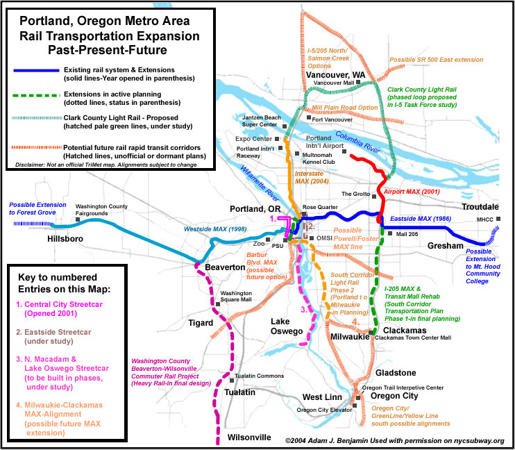
Future Portland Rail Transit Map (Credit: www.nycsubway.org)

Note: Solid Blue, Yellow and Red already built and operating
Dashed Green to Clackamas under construction (opening in September)
Dashed Purple from Beaverton already operating (although as Commuter Rail)
Dashed Orange to Milwaukie design/engineering underway. To begin construction after Green line opens.
Kind of difficult to see, but across from downtown a new Streetcar line should begin construction soon.

Total Mileage built and Operating = about 66 miles (44 Max, 7.2 Streetcar, 15 Commuter Rail) (Although I would personally consider the Streetcar to have 3.9 miles, but its listed as 7.2 because it forms a loop)
Total when Orange/Green lines open = about 80 miles
Reply With Quote
     
     
  #27  
Old Posted Mar 31, 2009, 4:31 PM
quashlo quashlo is offline
Registered User
 
Join Date: Sep 2006
Posts: 566
A thumbnail of my own geographically-accurate map of Central Tōkyō, made using Adobe Illustrator.
Through-service is shown in lighter colors.


Last edited by quashlo; Mar 31, 2009 at 11:41 PM.
Reply With Quote
     
     
  #28  
Old Posted Mar 31, 2009, 6:26 PM
JDRCRASH JDRCRASH is offline
Registered User
 
Join Date: Mar 2007
Location: San Gabriel Valley
Posts: 8,087
Quote:
Originally Posted by Westsidelife View Post
^

I don't understand why people keep on posting that map. It's pure fantasy.
Even if it doesn't happen, is there any problem with dreaming?
__________________
Revelation 21:4
Reply With Quote
     
     
  #29  
Old Posted Mar 31, 2009, 6:45 PM
BrandonJXN's Avatar
BrandonJXN BrandonJXN is offline
Ascension
 
Join Date: Nov 2004
Location: Riverside, California
Posts: 5,406
Tucson today:


Tucson in 2011

Video Link
__________________
Washed Out
Reply With Quote
     
     
  #30  
Old Posted Mar 31, 2009, 8:27 PM
Urban_logic's Avatar
Urban_logic Urban_logic is offline
Registered User
 
Join Date: Dec 2008
Location: Sandy, UT
Posts: 360
Quote:
Originally Posted by BTinSF View Post
San Francisco Bay Area...
Yay Bay Area!!! I love transportation in the Bay - it's so fast and convenient. You can pretty much go wherever you want without a car. There are some areas of improvement, though. Particularly the Hilsborough area, Oakland's east benches, and the north bay. I would also like to see better north-south rapid rail transit in the east bay - maybe building a BART line from Walnut Creek through Danville, San Ramon, Dublin/Pleasanton, and ending in San Jose. Then, of course, extend the Fremont and Milbrae lines into San Jose to connect with it. Bay Area transportation is good, but we can make it EXCELLENT!!

Quote:
Originally Posted by arkhitektor View Post
Salt Lake City...
SLC has come so far so quickly! Just a decade ago, there wasn't any passenger rail besides Amtrac. Now, there are 25 miles of light-rail and 40 miles of commuter rail. Then, in just a few short years, it will more than double its light-rail by adding 3 new lines and extending an existing line along with exactly doubling its commuter rail from 40 miles to 80 miles by adding an additional line. And now funds have been appropriated for a street-car system in SLC Proper and talks of Ogden street-cars are underway! SLC has come a long way in 10 years and will go even further over the next 10 years!

Last edited by Cirrus; Apr 1, 2009 at 3:01 AM.
Reply With Quote
     
     
  #31  
Old Posted Apr 1, 2009, 3:01 AM
Cirrus's Avatar
Cirrus Cirrus is offline
cities|transit|croissants
 
Join Date: Jul 2001
Location: Washington, DC
Posts: 18,384
Hi. Can we not clutter a thread that's already got a lot of images with quoted reposts of the same images? Thanks.
__________________
writing | twitter | flickr | instagram | ssp photo threads
Reply With Quote
     
     
  #32  
Old Posted Apr 1, 2009, 3:06 AM
Cirrus's Avatar
Cirrus Cirrus is offline
cities|transit|croissants
 
Join Date: Jul 2001
Location: Washington, DC
Posts: 18,384
MayDay: The Silver line has *59* stations? What makes it "rapid" again?

quashlo: That's really cool. And it actually seems easier to comprehend than the diagrammatic map.
__________________
writing | twitter | flickr | instagram | ssp photo threads
Reply With Quote
     
     
  #33  
Old Posted Apr 1, 2009, 6:47 PM
fugacious224488 fugacious224488 is offline
Registered User
 
Join Date: Dec 2007
Posts: 36
BRUSSELS

Trams (streetcars) :


http://homepage.univie.ac.at/horst.p.../m/brussel.png

Metro:


RER (under construction) :


Last edited by fugacious224488; Apr 6, 2009 at 9:11 PM.
Reply With Quote
     
     
  #34  
Old Posted Apr 1, 2009, 10:09 PM
initiald's Avatar
initiald initiald is offline
Oak City
 
Join Date: Apr 2003
Location: Raleigh
Posts: 4,946
Seriously, nobody has posted MARTA yet? What happened to all the Atlanta people?


Reply With Quote
     
     
  #35  
Old Posted Apr 1, 2009, 10:41 PM
HooverDam's Avatar
HooverDam HooverDam is offline
Registered User
 
Join Date: Apr 2006
Location: Country Club Park, Greater Coronado, Midtown, Phoenix, Az
Posts: 4,610
Reply With Quote
     
     
  #36  
Old Posted Apr 1, 2009, 11:51 PM
Paris-New York City Paris-New York City is offline
Registered User
 
Join Date: Mar 2009
Location: New York City
Posts: 14
Here is for Paris:

Subway network - used for short distance - Zone 1


RER & Transilien network - used for medium & long distance - Zone 1 to Zone 6
Reply With Quote
     
     
  #37  
Old Posted Apr 2, 2009, 2:32 AM
SuburbanNation SuburbanNation is offline
Closed account
 
Join Date: Jan 2006
Posts: 1,116
Reply With Quote
     
     
  #38  
Old Posted Apr 2, 2009, 5:52 AM
mattropolis's Avatar
mattropolis mattropolis is online now
matt in the city
 
Join Date: May 2004
Location: BC
Posts: 356
Quote:
A thumbnail of my own geographically-accurate map of Central Tōkyō, made using Adobe Illustrator.
Through-service is shown in lighter colors.
Great map of Tokyo! I love it.
Reply With Quote
     
     
  #39  
Old Posted Apr 2, 2009, 6:05 AM
Shawn Shawn is offline
Moderator
 
Join Date: Jul 2001
Location: Tokyo
Posts: 5,941
Quote:
Originally Posted by quashlo View Post
A thumbnail of my own geographically-accurate map of Central Tōkyō, made using Adobe Illustrator.
Through-service is shown in lighter colors.

Very nicely done - I especially like your font choice.

What needs to be made clear also is that this map covers maybe 30% of Greater Tokyo's stations. The size and scope of metro Tokyo's rail is well beyond anything else on this planet. 25+ million passengers PER DAY!
Reply With Quote
     
     
  #40  
Old Posted Apr 2, 2009, 7:14 AM
Minato Ku's Avatar
Minato Ku Minato Ku is offline
Tokyo and Paris fan
 
Join Date: Jul 2006
Location: Paris, Montrouge
Posts: 4,168
Exactly.
40% of world passenger train journey are made in Japan.
Tokyo metropolitan area represent a large part of Japan train ridership.

Everybody could understand what this mean.
Reply With Quote
     
     
This discussion thread continues

Use the page links to the lower-right to go to the next page for additional posts
 
 
Reply

Go Back   SkyscraperPage Forum > Discussion Forums > Transportation
Forum Jump


Forum Jump


All times are GMT. The time now is 5:37 PM.

     
SkyscraperPage.com - Archive - Privacy Statement - Top

Powered by vBulletin® Version 3.8.7
Copyright ©2000 - 2024, vBulletin Solutions, Inc.