HomeDiagramsDatabaseMapsForum About
     

Go Back   SkyscraperPage Forum > Photography Forums > My City Photos


Reply

 
Thread Tools Display Modes
     
     
  #1  
Old Posted Apr 19, 2024, 3:30 AM
FrAnKs's Avatar
FrAnKs FrAnKs is offline
Registered User
 
Join Date: Jul 2005
Location: Ville de Québec / Quebec city
Posts: 5,704
Trait-Carré, you're so cute!

Established in 1665 during the French regime, Trait-Carré is the oldest part of the Charlesbourg district of Québec City


__________________
PROVINCE OF QUEBEC ==> 9 000 000
MONTREAL METRO ==> 4 550 000
QUEBEC CITY METRO ==> 878 000

Last edited by FrAnKs; Apr 19, 2024 at 4:45 AM.
Reply With Quote
     
     
  #2  
Old Posted Apr 19, 2024, 4:05 AM
xzmattzx's Avatar
xzmattzx xzmattzx is offline
Registered User
 
Join Date: May 2006
Location: Wilmington, DE
Posts: 6,366
Nice pictures!

I looked up Trait-Carre and Charlesbourg. I have noticed Charlesbourg when exploring Google Maps, and wondered why it had a somewhat radial street plan. I wondered if the central square had any significance. Your pictures answer the latter question! How far out from the center do the historic buildings go?
Reply With Quote
     
     
  #3  
Old Posted Apr 19, 2024, 4:22 AM
FrAnKs's Avatar
FrAnKs FrAnKs is offline
Registered User
 
Join Date: Jul 2005
Location: Ville de Québec / Quebec city
Posts: 5,704
Quote:
Originally Posted by xzmattzx View Post
Nice pictures!

I looked up Trait-Carre and Charlesbourg. I have noticed Charlesbourg when exploring Google Maps, and wondered why it had a somewhat radial street plan. I wondered if the central square had any significance. Your pictures answer the latter question! How far out from the center do the historic buildings go?
Thanks! Here, ''radial'' is what we call a ''Star Shaped'' street grid which is directly inspired by some villages in Europe.

Until the 50's, Charlesbourg used to be a small village in the outskirts of Québec City and that's why the historic part is fairly limited but still very interesting!

Here's Charlesbourg in 1937. This area is now filled of billion of bungalows until the foothills...


There's another former star shaped village called ''Bourg-Royal'' about 2,5km to the northeast that looks like this aswell.
__________________
PROVINCE OF QUEBEC ==> 9 000 000
MONTREAL METRO ==> 4 550 000
QUEBEC CITY METRO ==> 878 000

Last edited by FrAnKs; Apr 19, 2024 at 4:41 AM.
Reply With Quote
     
     
  #4  
Old Posted Apr 19, 2024, 4:52 AM
xzmattzx's Avatar
xzmattzx xzmattzx is offline
Registered User
 
Join Date: May 2006
Location: Wilmington, DE
Posts: 6,366
Thanks! What is the point of the star-shaped street plan? I know that the ribbon farms that you find in French-settled areas were to give as many people as possible river access, as opposed to more square farm plots in English settlements, for instance.
Reply With Quote
     
     
  #5  
Old Posted Apr 22, 2024, 6:48 PM
FrAnKs's Avatar
FrAnKs FrAnKs is offline
Registered User
 
Join Date: Jul 2005
Location: Ville de Québec / Quebec city
Posts: 5,704
Quote:
Originally Posted by xzmattzx View Post
Thanks! What is the point of the star-shaped street plan? I know that the ribbon farms that you find in French-settled areas were to give as many people as possible river access, as opposed to more square farm plots in English settlements, for instance.
That's a good question!

Here's what I have found online about it:

(Translated from French)
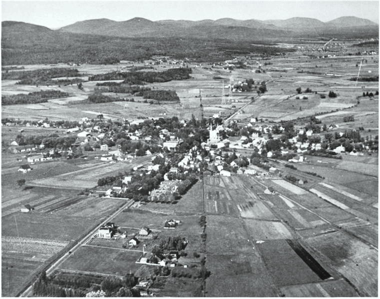
''So, in February 1665, the Jesuits applied in their stronghold Notre-Dame-des-Anges a division of lands unknown until now in this country.
Instead of a rectilinear row where the inhabitants are separated from each other and instead of a village where they would be grouped apart
of their lands, here, imagined by the Jesuits, is a habitat in the form of a star: each inhabitant, holder of a lot has forty acres in trapezoid shape
(and not triangle, as it is often written), lives on his land, only about thirty meters from his neighbors, while being part of the village.''

I had no idea myself...and I think it is pretty smart!

I think the absence of a large river in Charlesbourg and Bourg-Royal may explain why they could make it.

Here's a map made by Gédéon de Catalogne in 1709:

__________________
PROVINCE OF QUEBEC ==> 9 000 000
MONTREAL METRO ==> 4 550 000
QUEBEC CITY METRO ==> 878 000
Reply With Quote
     
     
  #6  
Old Posted Today, 12:25 AM
geomorph's Avatar
geomorph geomorph is offline
Registered User
 
Join Date: Aug 2009
Location: Newport Beach
Posts: 3,582
Interesting layout, how far is it from the center?
Reply With Quote
     
     
  #7  
Old Posted Today, 2:44 AM
FrAnKs's Avatar
FrAnKs FrAnKs is offline
Registered User
 
Join Date: Jul 2005
Location: Ville de Québec / Quebec city
Posts: 5,704
Quote:
Originally Posted by geomorph View Post
Interesting layout, how far is it from the center?
From Downtown Quebec city? About 6km.
__________________
PROVINCE OF QUEBEC ==> 9 000 000
MONTREAL METRO ==> 4 550 000
QUEBEC CITY METRO ==> 878 000
Reply With Quote
     
     
End
 
 
Reply

Go Back   SkyscraperPage Forum > Photography Forums > My City Photos
Forum Jump


Forum Jump


All times are GMT. The time now is 6:36 AM.

     
SkyscraperPage.com - Archive - Privacy Statement - Top

Powered by vBulletin® Version 3.8.7
Copyright ©2000 - 2024, vBulletin Solutions, Inc.